
Thank you for supporting this site ❤️
Make a donation
Make a donation
Kalutara District topographic map
Click on the map to display elevation.
Thank you for supporting this site ❤️
Make a donation
Make a donation
About this map
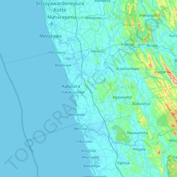
Name: Kalutara District topographic map, elevation, terrain.
Location: Kalutara District, Western Province, Sri Lanka (6.32486 79.70381 6.82407 80.38127)
Average elevation: 46 m
Minimum elevation: -3 m
Maximum elevation: 882 m
Thank you for supporting this site ❤️
Make a donation
Make a donation
Other topographic maps
Click on a map to view its topography, its elevation and its terrain.
Thank you for supporting this site ❤️
Make a donation
Make a donation
Thank you for supporting this site ❤️
Make a donation
Make a donation
Thank you for supporting this site ❤️
Make a donation
Make a donation
Thank you for supporting this site ❤️
Make a donation
Make a donation
Thank you for supporting this site ❤️
Make a donation
Make a donation
Thank you for supporting this site ❤️
Make a donation
Make a donation
Rathmalana North
Sri Lanka > Western Province > Mount Lavinia > Rathmalana North
Average elevation: 7 m
Thank you for supporting this site ❤️
Make a donation
Make a donation
Meethotamulla
Sri Lanka > Western Province > Kolonnawa > Maligawatte > Meethotamulla
Average elevation: 9 m
Thank you for supporting this site ❤️
Make a donation
Make a donation
Thank you for supporting this site ❤️
Make a donation
Make a donation
Thank you for supporting this site ❤️
Make a donation
Make a donation
Thank you for supporting this site ❤️
Make a donation
Make a donation
Thank you for supporting this site ❤️
Make a donation
Make a donation