
Galle Face Green topographic map
Interactive map
Click on the map to display elevation.
About this map
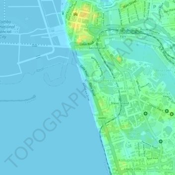
Name: Galle Face Green topographic map, elevation, terrain.
Average elevation: 5 m
Minimum elevation: 0 m
Maximum elevation: 26 m
Other topographic maps
Click on a map to view its topography, its elevation and its terrain.
Hyde Park
Sri Lanka > Western Province > Colombo > Slave Island
Hyde Park, Ibbanwala Junction, Hunupitiya, Slave Island, Colombo, Colombo District, Western Province, Sri Lanka
Average elevation: 12 m