
Thank you for supporting this site ❤️
Make a donation
Make a donation
Rathmalana topographic map
Click on the map to display elevation.
Thank you for supporting this site ❤️
Make a donation
Make a donation
About this map
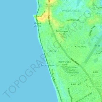
Name: Rathmalana topographic map, elevation, terrain.
Location: Rathmalana, Colombo District, Western Province, 10370, Sri Lanka (6.79975 79.84826 6.83975 79.88826)
Average elevation: 6 m
Minimum elevation: 0 m
Maximum elevation: 22 m
Thank you for supporting this site ❤️
Make a donation
Make a donation
Other topographic maps
Click on a map to view its topography, its elevation and its terrain.
Thank you for supporting this site ❤️
Make a donation
Make a donation
Thank you for supporting this site ❤️
Make a donation
Make a donation
Thank you for supporting this site ❤️
Make a donation
Make a donation
Thank you for supporting this site ❤️
Make a donation
Make a donation
Thank you for supporting this site ❤️
Make a donation
Make a donation