
Thank you for supporting this site ❤️
Make a donation
Make a donation
Kosgama topographic map
Click on the map to display elevation.
Thank you for supporting this site ❤️
Make a donation
Make a donation
About this map
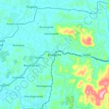
Name: Kosgama topographic map, elevation, terrain.
Location: Kosgama, Colombo District, Western Province, 10730, Sri Lanka (6.90063 80.09706 6.98063 80.17706)
Average elevation: 43 m
Minimum elevation: -1 m
Maximum elevation: 233 m
Thank you for supporting this site ❤️
Make a donation
Make a donation
Other topographic maps
Click on a map to view its topography, its elevation and its terrain.
Thank you for supporting this site ❤️
Make a donation
Make a donation
Thank you for supporting this site ❤️
Make a donation
Make a donation
Thank you for supporting this site ❤️
Make a donation
Make a donation
Thank you for supporting this site ❤️
Make a donation
Make a donation
Thank you for supporting this site ❤️
Make a donation
Make a donation