
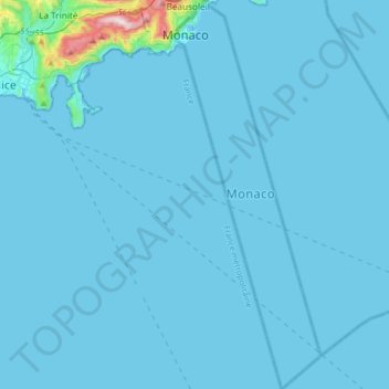
Monaco topographic map
Interactive map
Click on the map to display elevation.
About this map
Name: Monaco topographic map, elevation, terrain.
Location: Monaco (43.51654 7.40903 43.75193 7.53299)
Average elevation: 21 m
Minimum elevation: -1 m
Maximum elevation: 697 m
The four traditional quartiers of Monaco are Monaco-Ville, La Condamine, Monte Carlo and Fontvieille. However, the suburb of Moneghetti, the high-level part of La Condamine, is generally seen today as an effective fifth Quartier of Monaco, having a very distinct atmosphere and topography when compared with low-level La Condamine.
Other topographic maps
Click on a map to view its topography, its elevation and its terrain.
India
India
Average elevation: 1,017 m
Montreal
Canada > Quebec > Urban agglomeration of Montreal > Montreal
Montreal, Urban agglomeration of Montreal, Montreal (06), Quebec, H3B 1M7, Canada
Average elevation: 30 m
Hyderabad
India > Telangana > Bahadurpura mandal
Hyderabad, Bahadurpura mandal, Hyderabad District, Telangana, India
Average elevation: 549 m
Sri Lanka
Sri Lanka
Average elevation: 50 m
Snohomish County
Snohomish County, Washington, United States
Average elevation: 649 m
Charmouth
United Kingdom > England > Dorset
Charmouth, Dorset, England, United Kingdom
Average elevation: 50 m
Municipio Caracollo
Bolivia > Oruro > Provincia Cercado
Municipio Caracollo, Provincia Cercado, Oruro, Bolivia
Average elevation: 3,921 m
Tacoma
United States > Washington > Pierce County
Tacoma, Pierce County, Washington, United States
Average elevation: 67 m
Bhatwari
Bhatwari, Uttarkashi District, Uttarakhand, India
Average elevation: 4,570 m
Haywood County
United States > North Carolina
Haywood County, North Carolina, United States
Average elevation: 1,044 m
Ooty Lake
India > Tamil Nadu > Udhagamandalam > Udhagamandalam
Ooty Lake, Udhagamandalam, The Nilgiris District, Tamil Nadu, 643001, India
Average elevation: 2,235 m
Vadodara
India > Gujarat > Vadodara Taluka
Vadodara, Vadodara Taluka, Vadodara District, Gujarat, 390001, India
Average elevation: 36 m
Huzur Nagar Tahsil
Huzur Nagar Tahsil, Rewa District, Madhya Pradesh, India
Average elevation: 145 m
Kandy
Kandy, Kandy District, Central Province, 20000, Sri Lanka
Average elevation: 621 m
Thiruvananthapuram
India > Kerala > Thiruvananthapuram
Thiruvananthapuram, Thiruvananthapuram District, Kerala, 695001, India
Average elevation: 33 m
Nepal
Nepal
Average elevation: 2,604 m
Monte Pellecchia
Italy > Lazio > Rieti > Scandriglia
Monte Pellecchia, Scandriglia, Rieti, Lazio, Italy
Average elevation: 1,064 m
Begur Lake
India > Karnataka > Bangalore South
Begur Lake, Beguru, Bangalore South, Bengaluru Urban, Karnataka, India
Average elevation: 904 m
Polavaram
India > Andhra Pradesh > Kanigiri
Polavaram, Kanigiri, Prakasam, Andhra Pradesh, India
Average elevation: 93 m
Darjeeling district
Darjeeling district, West Bengal, India
Average elevation: 728 m
Navi Mumbai
India > Maharashtra > Thane > Navi Mumbai
Navi Mumbai, Mumbai Metropolitan Region, Thane, Maharashtra, 400706, India
Average elevation: 30 m
Noida
India > Uttar Pradesh > Dadri
Noida, Dadri, Gautam Buddha Nagar District, Uttar Pradesh, 201301, India
Average elevation: 216 m
Surat
India > Gujarat > Katargam Taluka > Surat
Surat, Katargam Taluka, Surat, Gujarat, 395001, India
Average elevation: 11 m
Bengaluru
India > Karnataka > Bangalore North
Bengaluru, Bangalore North, Bengaluru Urban District, Karnataka, India
Average elevation: 881 m
Morteros
Argentina > Córdoba > Pedanía Libertad
Morteros, Municipio de Morteros, Pedanía Libertad, Departamento San Justo, Córdoba, X2421, Argentina
Average elevation: 98 m
Cologne
Germany > North Rhine – Westphalia
Cologne, North Rhine – Westphalia, Germany
Average elevation: 69 m
Asarva Taluka
Asarva Taluka, Ahmedabad District, Gujarat, India
Average elevation: 57 m
Nagrota
India > Himachal Pradesh > Jawali
Nagrota, Jawali, Kangra District, Himachal Pradesh, 176027, India
Average elevation: 461 m