
Make a donation
Uasin Gishu County topographic map
Click on the map to display elevation.
Make a donation
Uasin Gishu County
Uasin Gishu County is one of the 47 counties of Kenya located in the former Rift Valley Province. Eldoret has the county's largest population centre as well as its administrative and commercial centre. “It lies between longitudes 34 degrees 50’ east and 35 degrees 37’ West and latitudes 0 degrees 03’ South and 0 degrees 55’ North. It is a highland plateau with altitudes falling gently from 2,700 meters above sea level to about 1,500 meters above sea level. The topography is higher to the east and declines gently towards the western border”.
Make a donation
About this map
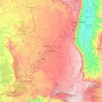
Name: Uasin Gishu County topographic map, elevation, terrain.
Location: Uasin Gishu County, Kenya (0.00649 34.85349 0.94350 35.59131)
Average elevation: 1,933 m
Minimum elevation: 1,007 m
Maximum elevation: 2,886 m
Make a donation
Other topographic maps
Click on a map to view its topography, its elevation and its terrain.
Make a donation
Sleeping Warrior (Delamare's Nose)
Kenya > Nakuru > Gilgil > Mbaruk/Eburu ward > Ututu
Average elevation: 1,850 m
Make a donation
Make a donation
Mombasa
Kenya > Mombasa County > Mvita
Being a coastal town, Mombasa is characterised by a flat topography. The town of Mombasa is centred on Mombasa Island, but extends to the mainland. The island is separated from the mainland by two creeks, Port Reitz in the south and Tudor Creek in the north.
Average elevation: 32 m
Make a donation
Make a donation
Make a donation
Nakuru
Kenya > Nakuru > Nakuru West
On 3 June 2021, Nakuru was officially endorsed for city status after the Kenyan Senate voted for its elevation from a municipality. Following the approval of the Senate of Kenya in June, the President of the Republic of Kenya gave a city charter for official transformation of Nakuru to a city status in…
Average elevation: 1,921 m