
Lautém topographic map
Interactive map
Click on the map to display elevation.
About this map
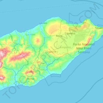
Name: Lautém topographic map, elevation, terrain.
Location: Lautém, East Timor (-8.96163 126.61002 -8.19645 127.54415)
Average elevation: 59 m
Minimum elevation: 0 m
Maximum elevation: 1,156 m
Other topographic maps
Click on a map to view its topography, its elevation and its terrain.
Pante Macassar
East Timor > Oecussi-Ambeno > Oecussi-Ambeno > Pante Macassar
Pante Macassar, Oecussi-Ambeno, Pante Macassar, Oecussi-Ambeno, East Timor
Average elevation: 144 m