
Liquiçá topographic map
Interactive map
Click on the map to display elevation.
About this map
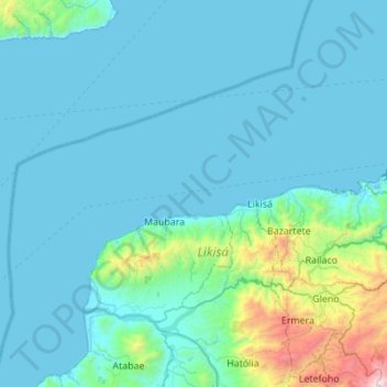
Name: Liquiçá topographic map, elevation, terrain.
Location: Liquiçá, East Timor (-8.75399 124.98304 -8.39519 125.53366)
Average elevation: 219 m
Minimum elevation: -1 m
Maximum elevation: 2,315 m
Other topographic maps
Click on a map to view its topography, its elevation and its terrain.
Pante Macassar
East Timor > Oecussi-Ambeno > Oecussi-Ambeno > Pante Macassar
Pante Macassar, Oecussi-Ambeno, Pante Macassar, Oecussi-Ambeno, East Timor
Average elevation: 144 m