Geolocate

Oecussi-Ambeno topographic map

Interactive map

Click on the map to display elevation.

About this map

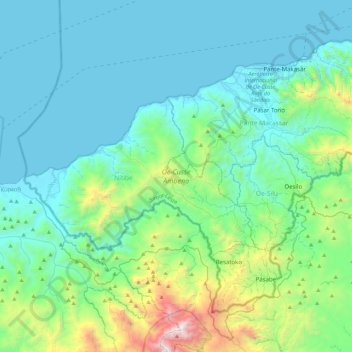
Name: Oecussi-Ambeno topographic map, elevation, terrain.

Location: Oecussi-Ambeno, East Timor (-9.50417 124.03175 -8.96583 124.49400)

Average elevation: 220 m

Minimum elevation: 0 m

Maximum elevation: 1,908 m

The temperature in Oecusse depends on elevation. In the coastal lowlands, it is about 31–33 °C (88–91 °F) in daytime (20–25 °C (68–77 °F) at night). With each 1,000 m (3,300 ft) of elevation, it decreases about 4–5 °C (39–41 °F). The annual precipitation rate is 1,000–2,500 mm (39–98 in). As in many parts of Timor, some areas become isolated in the rainy season because of flooding.

Wikipedia (CC-BY-SA 3.0)

Other topographic maps

Click on a map to view its topography, its elevation and its terrain.

Manufahi

East Timor

Manufahi, East Timor

Average elevation: 567 m

Baucau

East Timor

Baucau, East Timor

Average elevation: 222 m

Manatuto

East Timor

Manatuto, East Timor

Average elevation: 452 m

Aileu

East Timor

Aileu, East Timor

Average elevation: 862 m

Lautém

East Timor

Lautém, East Timor

Average elevation: 59 m

Ainaro

East Timor > Ainaro

Ainaro, East Timor

Average elevation: 898 m

Liquiçá

East Timor

Liquiçá, East Timor

Average elevation: 219 m

Bobonaro

East Timor

Bobonaro, East Timor

Average elevation: 576 m

Viqueque

East Timor

Viqueque, East Timor

Average elevation: 237 m

Pante Macassar

East Timor > Oecussi-Ambeno > Oecussi-Ambeno > Pante Macassar

Pante Macassar, Oecussi-Ambeno, Pante Macassar, Oecussi-Ambeno, East Timor

Average elevation: 144 m

Dili

East Timor > Dili

Dili, Vera Cruz, Dili, East Timor

Average elevation: 337 m

Fatuha

East Timor > Manatuto > Fatuha

Fatuha, Manatuto, East Timor

Average elevation: 1,165 m

Lahae

East Timor > Aileu > Lahae

Lahae, Aileu, East Timor

Average elevation: 1,204 m

Raenaba

East Timor > Liquiçá > Raenaba

Raenaba, Liquiçá, East Timor

Average elevation: 516 m