
Thank you for supporting this site ❤️
Make a donation
Make a donation
Bobonaro topographic map
Click on the map to display elevation.
Thank you for supporting this site ❤️
Make a donation
Make a donation
About this map
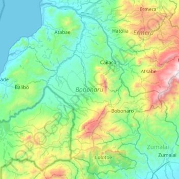
Name: Bobonaro topographic map, elevation, terrain.
Location: Bobonaro, East Timor (-9.21347 124.93176 -8.73584 125.43442)
Average elevation: 576 m
Minimum elevation: 0 m
Maximum elevation: 2,673 m
Thank you for supporting this site ❤️
Make a donation
Make a donation
Other topographic maps
Click on a map to view its topography, its elevation and its terrain.
Dili
The main city lies within an area of flat lowlands of less than 100m altitude, mostly between 0 and 60m, and a slope under 15 degrees. This includes an alluvial plain, and a number of beaches line the coast. The soil underneath this plain is quaternary alluvium. The distance between the sea and the mountains…
Average elevation: 337 m
Thank you for supporting this site ❤️
Make a donation
Make a donation