
South Carolina topographic map
Interactive map
Click on the map to display elevation.
South Carolina
South Carolina's topography is defined by three major geographic regions: the Atlantic Coastal Plain, the Piedmont, and the Blue Ridge Mountains. Covering approximately two-thirds of the state, the Atlantic Coastal Plain is characterized by flat, gently rolling terrain that transitions from the sandy beaches along the Atlantic Ocean to swamps and estuaries further inland. The coastal areas are interspersed with barrier islands and unique features like Carolina bays—elliptical depressions formed by various geological processes. Moving inland, the Piedmont region features rolling hills and elevated plateaus, with elevations generally ranging from 400 to 1,200 feet (122 to 366 meters), and includes the distinctive fall line where the rivers descend to the lower coastal plain. The northwest corner of the state rises into the Blue Ridge Mountains, with Sassafras Mountain as the highest point at 3,560 feet (1,085 meters). This area is known for its rugged terrain, steep slopes, and rich biodiversity. Overall, South Carolina's diverse topography reflects a rich geological history influenced by ancient mountains, river systems, and coastal dynamics.
About this map
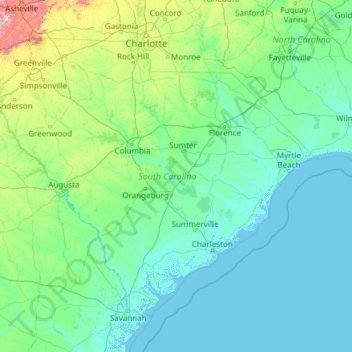
Name: South Carolina topographic map, elevation, terrain.
Location: South Carolina, United States (32.03345 -83.35400 35.21549 -78.54135)
Average elevation: 85 m
Minimum elevation: -4 m
Maximum elevation: 1,642 m
Other topographic maps
Click on a map to view its topography, its elevation and its terrain.
Tallahassee
United States > Florida > Leon County > Tallahassee
Tallahassee's terrain is hilly by Florida standards, being at the southern end of the Red Hills Region, just above the Cody Scarp. The elevation varies from near sea level to just over 200 feet (61 m), with the state capitol on one of the highest hills in the city. The city includes two large lake basins, Lake…
Average elevation: 32 m
Kula
United States > Hawaii > Maui County
Kula is a district and census-designated place (CDP) of Maui, Hawaii, that stretches across the "up-country", the western-facing slopes of Haleakalā, from Makawao to Kanaio. Most of the residential areas lie between about 500 to 1,100 m (1,600 to 3,600 ft) in elevation. The district has traditionally been…
Average elevation: 740 m
Austrailia Beach
United States > Connecticut > Southeastern Connecticut Planning Region > Stonington > Mystic
Average elevation: 19 m
Lake Ella
United States > Florida > Leon County > Tallahassee
In 1986, Lake Ella underwent extensive rehabilitation including sediment removal, reshaping of the shoreline, reducing the number of stormwater inflow pipes, and installation of an automatic alum treatment system. Lake Ella receives stormwater runoff from an urban watershed that is approximately 157 acres…
Average elevation: 56 m
McCormick's Creek State Park
United States > Indiana > Owen County
The heart of the park is McCormick's Creek Canyon. The upper levels of the canyon are around 700 feet (210 m) above sea levels, dropping to the west fork of the White River which is near 540 feet (160 m). The McCormick's Creek waterfall is a primary attraction of the park, as Indiana has few waterfalls due to…
Average elevation: 205 m
Culmerville
United States > Pennsylvania > Allegheny County > West Deer Township
Average elevation: 341 m
Deep Creek
United States > Virginia > Accomack County
It lies at an elevation of 3 feet.
Average elevation: 1 m
South Gulf Cove Park
United States > Florida > Charlotte County > Port Charlotte
Average elevation: 3 m
Central Park
United States > New York > New York County > New York
In June 1856, Fernando Wood appointed a "consulting board" of seven people, headed by author Washington Irving, to inspire public confidence in the proposed development. Wood hired military engineer Egbert Ludovicus Viele as the park's chief engineer, tasking him with a topographical survey of the site. The…
Average elevation: 26 m
Shady Groove Park And Baseball Field
United States > Mississippi > George County > Central
Average elevation: 60 m
Rocky Butte
United States > Oregon > Multnomah County > Portland
Rocky Butte lies in the northeast part of Portland within the city limits, in Multnomah County, part of the U. S. state of Oregon. It is one of the few smaller volcanic cones within or near Portland, along with Mount Tabor, Kelly Butte, and Powell Butte. According to the U.S. National Geodetic Survey, Rocky…
Average elevation: 67 m
San Juan South Estates Colonia
United States > Texas > Hidalgo County > San Juan
Average elevation: 34 m
Rancocas Woods
United States > New Jersey > Burlington County > Mount Laurel Township
Average elevation: 12 m
Hillsborough River Estates
United States > Florida > Hillsborough County > Tampa
Average elevation: 14 m
Lakeland Highlands
United States > Florida > Polk County > Bartow > Lakeland Highlands
Average elevation: 64 m
Lake Sal Dam
United States > Georgia > Bulloch County > Statesboro > Pate Place
Average elevation: 64 m
Lituya Glacier
United States > Alaska > Unorganized Borough
It is partially responsible for creating the 1958 Lituya Bay megatsunami. The glacier, which has receded over the years, carved Lituya Bay into a unique topographic phenomenon with steep walls, a very deep submerged bottom, and a very narrow entrance to the ocean which created the opportunity for a megatsunami…
Average elevation: 952 m
Brawley
United States > California > Imperial County
Brawley is located in the Colorado Desert and Lower Colorado River Valley regions. The city's elevation, like other Imperial Valley towns, is below sea level.
Average elevation: -44 m
Jupiter Inlet Light
United States > Florida > Palm Beach County > Jupiter
The Jupiter Inlet Light is located in Jupiter, Florida, on the north side of the Jupiter Inlet. The site for the lighthouse was chosen in 1853. It is located between Cape Canaveral Light and Hillsboro Inlet Light. The lighthouse was designed by then Lieutenant George G. Meade of the Bureau of Topographical…
Average elevation: 4 m
Lacamas Lake Shoreline Open Space
United States > Washington > Clark County > Camas
Average elevation: 106 m
Bodie
United States > California > Mono County
Bodie (/ˈboʊdiː/ BOH-dee) is a ghost town in the Bodie Hills east of the Sierra Nevada mountain range in Mono County, California, United States. It is about 75 miles (121 km) southeast of Lake Tahoe, and 12 mi (19 km) east-southeast of Bridgeport, at an elevation of 8,379 feet (2554 m). Bodie became a boom…
Average elevation: 2,627 m