
Washington topographic map
Click on the map to display elevation.
Washington
Washington is the 18th largest state, with an area of 71,362 square miles (184,827 km2), and the 13th most populous state, with more than 7.4 million people. Approximately 60 percent of Washington's residents live in the Seattle metropolitan area, the center of transportation, business, and industry along Puget Sound, an inlet of the Pacific Ocean consisting of numerous islands, deep fjords, and bays carved out by glaciers. The remainder of the state consists of deep temperate rainforests in the west; mountain ranges in the west, central, northeast, and far southeast; and a semi-arid basin region in the east, central, and south, given over to intensive agriculture. Washington is the second most populous state on the West Coast and in the Western United States, after California. Mount Rainier, an active stratovolcano, is the state's highest elevation, at almost 14,411 feet (4,392 meters), and is the most topographically prominent mountain in the contiguous U.S.
About this map
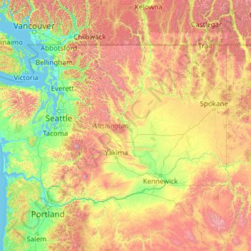
Name: Washington topographic map, elevation, terrain.
Location: Washington, United States (45.54373 -124.83609 49.00244 -116.91599)
Average elevation: 796 m
Minimum elevation: -2 m
Maximum elevation: 4,170 m
Other topographic maps
Click on a map to view its topography, its elevation and its terrain.
Tallahassee
United States > Florida > Leon County > Tallahassee
Tallahassee's terrain is hilly by Florida standards, being at the southern end of the Red Hills Region, just above the Cody Scarp. The elevation varies from near sea level to just over 200 feet (61 m), with the state capitol on one of the highest hills in the city. The city includes two large lake basins, Lake…
Average elevation: 32 m
Kula
United States > Hawaii > Maui County
Kula is a district and census-designated place (CDP) of Maui, Hawaii, that stretches across the "up-country", the western-facing slopes of Haleakalā, from Makawao to Kanaio. Most of the residential areas lie between about 500 to 1,100 m (1,600 to 3,600 ft) in elevation. The district has traditionally been…
Average elevation: 740 m
Culmerville
United States > Pennsylvania > Allegheny County > West Deer Township
Average elevation: 341 m
Rancocas Woods
United States > New Jersey > Burlington County > Mount Laurel Township
Average elevation: 12 m
Mountain Village
United States > Colorado > San Miguel County
Mountain Village is a home rule municipality in San Miguel County, southwestern Colorado. It is located just southwest of Telluride, Colorado in the San Juan Mountains. The elevation of the town rises above Telluride to 9,600 feet. The population was 1,264 at the 2020 census.
Average elevation: 2,917 m
Salton Sea
United States > California > CAL Fire San Diego Unit
The Gulf of California would extend as far north as the city of Indio, were it not for the delta created by the Colorado River. Over three million years, through all of the Pleistocene, the river's delta expanded until it cut off the northern part of the gulf. Since then, the Colorado River has alternated…
Average elevation: 8 m
Mount Rushmore
United States > South Dakota > Pennington County
The Mount Rushmore National Memorial is a national memorial centered on a colossal sculpture carved into the granite face of Mount Rushmore (Lakota: Tȟuŋkášila Šákpe, or Six Grandfathers) in the Black Hills near Keystone, South Dakota, United States. Sculptor Gutzon Borglum designed the sculpture, called…
Average elevation: 1,562 m
Half Dome
United States > California > Mariposa County
The Half Dome Cable Route hike runs from the valley floor to the top of the dome in 8.2 mi (13 km) (via the Mist Trail), with 4,800 ft (1,460 m) of elevation gain. The length and difficulty of the trail used to keep it less crowded than other park trails, but in recent years the trail traffic has grown to as…
Average elevation: 1,887 m
Ellisdale
United States > New Jersey > Monmouth County > Upper Freehold Township
Average elevation: 34 m
Mount Saint Helens
United States > Washington > Skamania County
Mount St. Helens is best known for its major eruption on May 18, 1980, the deadliest and most economically destructive volcanic event in U.S. history. Fifty-seven people were killed; 200 homes, 47 bridges, 15 miles (24 km) of railways, and 185 miles (298 km) of highway were destroyed. A massive debris…
Average elevation: 2,096 m
Roxbury
United States > Connecticut > Western Connecticut Planning Region > Stamford
Average elevation: 48 m
Sierra Vista Open Space Preserve
United States > California > Santa Clara County > San Jose
Average elevation: 484 m
McCormick's Creek State Park
United States > Indiana > Owen County
The heart of the park is McCormick's Creek Canyon. The upper levels of the canyon are around 700 feet (210 m) above sea levels, dropping to the west fork of the White River which is near 540 feet (160 m). The McCormick's Creek waterfall is a primary attraction of the park, as Indiana has few waterfalls due to…
Average elevation: 205 m
Lituya Glacier
United States > Alaska > Unorganized Borough
It is partially responsible for creating the 1958 Lituya Bay megatsunami. The glacier, which has receded over the years, carved Lituya Bay into a unique topographic phenomenon with steep walls, a very deep submerged bottom, and a very narrow entrance to the ocean which created the opportunity for a megatsunami…
Average elevation: 952 m
South Gulf Cove Park
United States > Florida > Charlotte County > Port Charlotte
Average elevation: 3 m
Hillsborough River Estates
United States > Florida > Hillsborough County > Tampa
Average elevation: 14 m
Quarry Heights
United States > New York > Westchester County > Town/Village of Harrison
Average elevation: 112 m
Rocky Butte
United States > Oregon > Multnomah County > Portland
Rocky Butte lies in the northeast part of Portland within the city limits, in Multnomah County, part of the U. S. state of Oregon. It is one of the few smaller volcanic cones within or near Portland, along with Mount Tabor, Kelly Butte, and Powell Butte. According to the U.S. National Geodetic Survey, Rocky…
Average elevation: 67 m
Jupiter Inlet Light
United States > Florida > Palm Beach County > Jupiter
The Jupiter Inlet Light is located in Jupiter, Florida, on the north side of the Jupiter Inlet. The site for the lighthouse was chosen in 1853. It is located between Cape Canaveral Light and Hillsboro Inlet Light. The lighthouse was designed by then Lieutenant George G. Meade of the Bureau of Topographical…
Average elevation: 4 m
Monument
United States > Colorado > El Paso County
Monument experiences a hemiboreal continental climate (Köppen Dfb) with warm, relatively rainy summers and cold, snowy winters. The semi-arid climate keeps the dew point very low in Monument year-round which causes the air to feel quite dry. Monument is part of the Front Range urban corridor and lies on the…
Average elevation: 2,160 m
Lacamas Lake Shoreline Open Space
United States > Washington > Clark County > Camas
Average elevation: 106 m