
Thank you for supporting this site ❤️
Make a donation
Make a donation
South Guardian Angel topographic map
Click on the map to display elevation.
Thank you for supporting this site ❤️
Make a donation
Make a donation
About this map
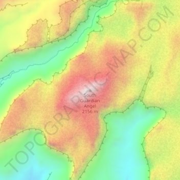
Name: South Guardian Angel topographic map, elevation, terrain.
Average elevation: 1,773 m
Minimum elevation: 1,398 m
Maximum elevation: 2,168 m
Thank you for supporting this site ❤️
Make a donation
Make a donation
Other topographic maps
Click on a map to view its topography, its elevation and its terrain.
St. George
United States > Utah > Washington County > St. George
The St. George valley does occasionally receive wet or slushy snowfall in the winter, but what accumulates usually melts off by the mid-to-late morning; the normal seasonal snowfall is 1.4 inches (3.6 cm). The earliest snowfall was measured on October 29, 1971, and the latest on April 11, 1927. The record…
Average elevation: 929 m