
Georgia topographic map
Interactive map
Click on the map to display elevation.
About this map
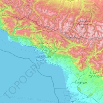
Name: Georgia topographic map, elevation, terrain.
Location: Abkhazia, Georgia (42.40717 39.88448 43.58643 42.14037)
Average elevation: 935 m
Minimum elevation: -4 m
Maximum elevation: 3,962 m
Abkhazia is diverse geographically with lowlands stretching to the extremely mountainous north. The Greater Caucasus Mountain Range runs along the region's northern border, with its spurs – the Gagra, Bzyb and Kodori ranges – dividing the area into a number of deep, well-watered valleys. The highest peaks of Abkhazia are in the northeast and east and several exceed 4,000 meters (13,123 ft) above sea level. Abkhazia's landscape ranges from coastal forests and citrus plantations to permanent snows and glaciers in the north of the region. Although Abkhazia's complex topographic setting has spared most of the territory from significant human development, its cultivated fertile lands produce tea, tobacco, wine and fruits, a mainstay of the local agricultural sector.
Other topographic maps
Click on a map to view its topography, its elevation and its terrain.
India
India
Average elevation: 1,017 m
Sri Lanka
Sri Lanka
Average elevation: 50 m
Montreal
Canada > Quebec > Urban agglomeration of Montreal > Montreal
Montreal, Urban agglomeration of Montreal, Montreal (06), Quebec, H3B 1M7, Canada
Average elevation: 30 m
Hyderabad
India > Telangana > Bahadurpura mandal
Hyderabad, Bahadurpura mandal, Hyderabad District, Telangana, India
Average elevation: 549 m
Snohomish County
Snohomish County, Washington, United States
Average elevation: 649 m
Bengaluru
India > Karnataka > Bangalore North
Bengaluru, Bangalore North, Bengaluru Urban District, Karnataka, India
Average elevation: 881 m
Ooty Lake
India > Tamil Nadu > Udhagamandalam > Udhagamandalam
Ooty Lake, Udhagamandalam, The Nilgiris District, Tamil Nadu, 643001, India
Average elevation: 2,235 m
Mangerton
Australia > New South Wales > Wollongong City Council
Mangerton, Wollongong City Council, New South Wales, 2500, Australia
Average elevation: 31 m
Sujanpur
India > Punjab > Pathankot Tahsil
Sujanpur, Pathankot Tahsil, Pathankot District, Punjab, 145023, India
Average elevation: 334 m
Tacoma
United States > Washington > Pierce County
Tacoma, Pierce County, Washington, United States
Average elevation: 67 m
Nepal
Nepal
Average elevation: 2,604 m
Gandhipuram
India > Tamil Nadu > Coonoor
Gandhipuram, Coonoor, Nilgiris District, Tamil Nadu, 643103, India
Average elevation: 1,686 m
Sion Fort
India > Maharashtra > Mumbai
Sion Fort, Road No 1, Sion Koliwada, F/N Ward, Zone 2, Mumbai, Maharashtra, 400022, India
Average elevation: 6 m
Mangaluru
India > Karnataka > Mangaluru taluk
Mangaluru, Mangaluru taluk, Dakshina Kannada District, Karnataka, 575001, India
Average elevation: 25 m
Colombo
Colombo, Colombo District, Western Province, Sri Lanka
Average elevation: 5 m
Siliguri
India > West Bengal > Siliguri Subdivsion
Siliguri, Siliguri Subdivsion, Darjeeling District, West Bengal, India
Average elevation: 121 m
Vadodara
India > Gujarat > Vadodara Taluka
Vadodara, Vadodara Taluka, Vadodara District, Gujarat, 390001, India
Average elevation: 36 m
Kharki
India > Madhya Pradesh > Pandhana Tahsil
Kharki, Pandhana Tahsil, Khandwa District, Madhya Pradesh, India
Average elevation: 317 m
Kannamedi
India > Karnataka > Pavagada taluk
Kannamedi, Pavagada taluk, Tumakuru District, Karnataka, India
Average elevation: 708 m
Hariharapura
India > Karnataka > Koppa taluk
Hariharapura, Koppa taluk, Chikkamagaluru District, Karnataka, 577120, India
Average elevation: 648 m
Pullalarevu
India > Andhra Pradesh > Raptadu
Pullalarevu, Raptadu, Anantapur, Andhra Pradesh, 515722, India
Average elevation: 389 m
Musti
India > Maharashtra > Solapur South
Musti, Solapur South, Solapur District, Maharashtra, 413573, India
Average elevation: 487 m
Mambakkam
India > Tamil Nadu > Tiruporur
Mambakkam, Tiruporur, Chengalpattu District, Tamil Nadu, 600127, India
Average elevation: 16 m
A`zaz
A`zaz, Azaz Subdistrict, Azaz District, Aleppo Governorate, Syria
Average elevation: 559 m
Pedda Arikatla
India > Andhra Pradesh > Konakanamitla
Pedda Arikatla, Konakanamitla, Prakasam, Andhra Pradesh, 523245, India
Average elevation: 119 m
Ocheretyne
Ocheretyne, Ocheretyne settlement hromada, Pokrovskii Raion, Donetsk Oblast, 86020, Ukraine
Average elevation: 227 m
Haywood County
United States > North Carolina
Haywood County, North Carolina, United States
Average elevation: 1,044 m
Cadomin
Canada > Alberta > Yellowhead County
Cadomin, Yellowhead County, Alberta, Canada
Average elevation: 1,605 m
Hinton
United States > Iowa > Plymouth County
Hinton, Plymouth County, Iowa, 51204, United States
Average elevation: 362 m