
Make a donation
Yunnan topographic map
Click on the map to display elevation.
Make a donation
Yunnan
Yunnan is situated in a mountainous area, with high elevations in the Northwest and low elevations in the Southeast. Most of the population lives in the eastern part of the province. In the west, the altitude can vary from the mountain peaks to river valleys as much as 3,000 m (9,800 ft). Yunnan is rich in natural resources and has the largest diversity of plant life in China. Of the approximately 30,000 species of higher plants in China, Yunnan has perhaps 17,000 or more. Yunnan's reserves of aluminium, lead, zinc and tin are the largest in China, and there are also major reserves of copper and nickel. Historically, the southwestern Silk Road to Bhitargarh in Bangladesh passed through modern Yunnan.
Make a donation
About this map
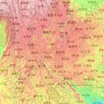
Name: Yunnan topographic map, elevation, terrain.
Location: Yunnan, China (21.14314 97.52746 29.22572 106.19675)
Average elevation: 1,713 m
Minimum elevation: 4 m
Maximum elevation: 6,431 m
Make a donation
Other topographic maps
Click on a map to view its topography, its elevation and its terrain.
Scarborough Shoal
China > Hainan Province > Sansha
The Philippines state that its assertion of sovereignty over the atoll is based on the juridical criteria established by public international law on the lawful methods for the acquisition of sovereignty. Among the criteria (effective occupation, cession, prescription, conquest, and accretion), the Philippine…
Average elevation: 0 m
Beijing
Beijing is situated at the northern tip of the roughly triangular North China Plain, which opens to the south and east of the city. Mountains to the north, northwest and west shield the city and northern China's agricultural heartland from the encroaching desert steppes. The northwestern part of the…
Average elevation: 47 m
Make a donation
Large High Altitude Air Shower Observatory
China > Sichuan > Daocheng County
The Large High Altitude Air Shower Observatory (LHAASO) is a gamma-ray and cosmic-ray observatory in Daocheng, in the Garzê Tibetan Autonomous Prefecture in Sichuan, China. It is designed to observe air showers triggered by gamma rays and cosmic rays. The observatory is at an altitude of 4,410 metres (14,470…
Average elevation: 4,421 m
Mischief Reef
China > Hainan Province > Sansha
Mischief Reef, also known as Panganiban Reef (Tagalog: Bahura ng Panganiban; Vietnamese: Đá Vành Khăn; Mandarin Chinese: 美濟礁/美济礁; pinyin: Měijì Jiāo; lit. 'Meiji Reef'), is a low tide elevation (LTE) reef/atoll surrounding a large lagoon in the SE of Dangerous Ground in the east of the…
Average elevation: 0 m
Make a donation
Make a donation
River Ganges (Ping Yuen River)
China > Hong Kong > North District > Ping Che > Ping Che Yuen Ha
Average elevation: 23 m
Make a donation
Lantau Peak
China > Hong Kong > Islands District
Lantau Peak is located in central Lantau Island, with an elevation of 934 meters above sea level (23 metres shorter than Tai Mo Shan, Hong Kong's highest peak). Under the Köppen climate classification, Lantau Peak features a subtropical highland climate. Due to its elevation, strong winds and fog occur…
Average elevation: 422 m
Make a donation
Subi Reef
China > Hainan Province > Nansha District
On 12 July 2016, the UNCLOS special arbitral tribunal in the Philippines v. China case confirmed that Subi Reef is, or in its natural condition was, exposed at low tide and submerged at high tide and is, accordingly a low-tide elevation that does not generate entitlement to a territorial sea, exclusive…
Average elevation: 0 m
Make a donation
Make a donation
Litang
China > Sichuan > Litang County
Litang County is located in the west of Sichuan, the southwest of Garze Tibetan Autonomous Prefecture, between the Jinsha River and the Yalong River on the southeastern edge of the Qinghai-Tibet Plateau. The Shaluli Mountains runs from north to south. The terrain is dominated by hill-shaped plateaus and…
Average elevation: 4,305 m
Make a donation
Make a donation
Wuzhi Mountain
China > Hainan Province > Qiongzhong Li and Miao Autonomous County
Average elevation: 1,217 m
Tsing Tam Lower Reservoir
China > Hong Kong > Yuen Long District > Lin Fa Tei > Cheung Po
Average elevation: 153 m
Make a donation
Tai Shui Hang Village
China > Hong Kong > Sha Tin District > Tai Shui Hang Village
Average elevation: 112 m
Make a donation
Mount Everest
China > Tibet > Tingri County
Mount Everest (Nepali: सगरमाथा, romanized: Sagarmāthā; Tibetan: Chomolungma ཇོ་མོ་གླང་མ; Chinese: 珠穆朗玛峰; pinyin: Zhūmùlǎngmǎ Fēng) is Earth's highest mountain above sea level, located in the Mahalangur Himal sub-range of the Himalayas. The China–Nepal…
Average elevation: 7,851 m
Make a donation
Shanghai
The golden age of Shanghai began with its elevation to municipality after it was separated from Jiangsu on 7 July 1927. This new Chinese municipality covered an area of 494.69 km2 (191.0 sq mi), including the modern-day districts of Baoshan, Yangpu, Zhabei, Nanshi, and Pudong, but excluded the foreign…
Average elevation: 5 m
Make a donation
Make a donation
Lhoka
China > Tibet > Tsetang Township
Shannan has 1 district and 11 counties and its capital is Tsetang, which is located 183 kilometres from Lhasa. It covers an area of 79,700 square kilometres (30,800 sq mi), which includes part of South Tibet, a disputed territory currently under control of the Indian state of Arunachal Pradesh. Its topography…
Average elevation: 4,148 m
Make a donation
Nagqu
Nagqu is located in the northeast of Tibet. Nagqu Town is 330 kilometres (210 mi) by the China National Highway 109 northeast of Lhasa. Nagqu is bordered by Bayingolin and Hotan Prefectures of Xinjiang to the north, Haixi, Yushu Prefectures of Qinghai and Chamdo to the east, Nyingchi, Lhasa and Shigatse to the…
Average elevation: 4,624 m
Lhamo Latso
China > Tibet > Gyatsa County > Cuijiu
Lhamo Latso... [is] a brilliant azure jewel set in a ring of grey mountains. The elevation and the surrounding peaks combine to give it a highly changeable climate, and the continuous passage of cloud and wind creates a constantly moving pattern on the surface of the waters. On that surface visions appear to…
Average elevation: 5,104 m
Make a donation