
Thank you for supporting this site ❤️
Make a donation
Make a donation
Kidney Hill topographic map
Click on the map to display elevation.
Thank you for supporting this site ❤️
Make a donation
Make a donation
About this map
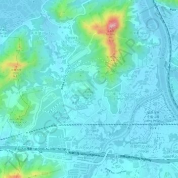
Name: Kidney Hill topographic map, elevation, terrain.
Average elevation: 27 m
Minimum elevation: -2 m
Maximum elevation: 169 m
Thank you for supporting this site ❤️
Make a donation
Make a donation
Other topographic maps
Click on a map to view its topography, its elevation and its terrain.
River Ganges (Ping Yuen River)
China > Hong Kong > North District > Ping Che > Ping Che Yuen Ha
Average elevation: 23 m