
Lantau Peak topographic map
Interactive map
Click on the map to display elevation.
Lantau Peak
Lantau Peak is located in central Lantau Island, with an elevation of 934 meters above sea level (23 metres shorter than Tai Mo Shan, Hong Kong's highest peak). Under the Köppen climate classification, Lantau Peak features a subtropical highland climate. Due to its elevation, strong winds and fog occur throughout the year. Winter is cold with temperatures often dipping below 0 °C; summer is warm with temperatures reaching tops of 18-22 °C; spring is cool and humid; autumn is cool and dry. Because there is no weather station at the top of Lantau Peak (934m), the Ngong Ping Weather Station of the Hong Kong Observatory (593m) can be used as reference for the temperature at the summit.
About this map
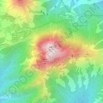
Name: Lantau Peak topographic map, elevation, terrain.
Average elevation: 422 m
Minimum elevation: 112 m
Maximum elevation: 885 m