
Bolivia topographic map
Interactive map
Click on the map to display elevation.
About this map
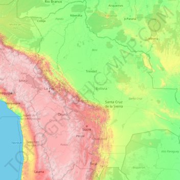
Name: Bolivia topographic map, elevation, terrain.
Location: Bolivia (-22.89827 -69.64501 -9.66894 -57.45300)
Average elevation: 1,136 m
Minimum elevation: 0 m
Maximum elevation: 6,250 m
The geography of the country exhibits a great variety of terrain and climates. Bolivia has a high level of biodiversity, considered one of the greatest in the world, as well as several ecoregions with ecological sub-units such as the Altiplano, tropical rainforests (including Amazon rainforest), dry valleys, and the Chiquitania, which is a tropical savanna. These areas feature enormous variations in altitude, from an elevation of 6,542 meters (21,463 ft) above sea level in Nevado Sajama to nearly 70 meters (230 ft) along the Paraguay River. Although a country of great geographic diversity, Bolivia has remained a landlocked country since the War of the Pacific. Puerto Suárez, San Matías and Puerto Quijarro are located in the Bolivian Pantanal.
Other topographic maps
Click on a map to view its topography, its elevation and its terrain.
India
India
Average elevation: 1,017 m
Montreal
Canada > Quebec > Urban agglomeration of Montreal > Montreal
Montreal, Urban agglomeration of Montreal, Montreal (06), Quebec, H3B 1M7, Canada
Average elevation: 30 m
Sri Lanka
Sri Lanka
Average elevation: 50 m
Nepal
Nepal
Average elevation: 2,604 m
Kandy
Kandy, Kandy District, Central Province, 20000, Sri Lanka
Average elevation: 621 m
Bengaluru
India > Karnataka > Bangalore North
Bengaluru, Bangalore North, Bengaluru Urban District, Karnataka, India
Average elevation: 881 m
Snohomish County
Snohomish County, Washington, United States
Average elevation: 649 m
Philippines
Philippines
Average elevation: 33 m
Surat
India > Gujarat > Katargam Taluka > Surat
Surat, Katargam Taluka, Surat, Gujarat, 395001, India
Average elevation: 11 m
Hyderabad
India > Telangana > Bahadurpura mandal
Hyderabad, Bahadurpura mandal, Hyderabad District, Telangana, India
Average elevation: 549 m
Yelahanka taluku
Yelahanka taluku, Bengaluru Urban, Karnataka, India
Average elevation: 898 m
Teaneck Township
United States > New Jersey > Bergen County
Teaneck Township, Bergen County, New Jersey, 07666, United States
Average elevation: 20 m
Bergen County
Bergen County, New Jersey, United States
Average elevation: 66 m
Ashtamudi
India > Kerala > Kollam > Thrikkaruva
Ashtamudi, Thrikkaruva, Kollam, Kollam District, Kerala, 691602, India
Average elevation: 7 m
Musi River
Musi River, Hyderabad, Uppal mandal, Medchal–Malkajgiri, Telangana, 5000036, India
Average elevation: 490 m
Wilkinson County
Wilkinson County, Georgia, United States
Average elevation: 104 m
Tacoma
United States > Washington > Pierce County
Tacoma, Pierce County, Washington, United States
Average elevation: 67 m
Thiruvananthapuram
India > Kerala > Thiruvananthapuram
Thiruvananthapuram, Thiruvananthapuram District, Kerala, 695001, India
Average elevation: 33 m
Rishikesh
India > Uttarakhand > Rishikesh
Rishikesh, Dehradun, Uttarakhand, 249201, India
Average elevation: 497 m
Carlsbad
United States > California > San Diego County
Carlsbad, San Diego County, California, United States
Average elevation: 24 m
Lower Acacia Creek
Lower Acacia Creek, Tenterfield Shire Council, New South Wales, 2476, Australia
Average elevation: 532 m
Devanahalli taluku
Devanahalli taluku, Bengaluru Rural, Karnataka, India
Average elevation: 907 m
Jefferson County
Jefferson County, Florida, United States
Average elevation: 23 m
Mathara
India > Maharashtra > Rajura Taluka
Mathara, Rajura Taluka, Chandrapur District, Maharashtra, India
Average elevation: 185 m
Anaikatti
India > Tamil Nadu > Coimbatore North
Anaikatti, Mannarkad, Palakkad District, Kerala, 678741, India
Average elevation: 623 m
Dahej
India > Gujarat > Vagra Taluka
Dahej, Vagra Taluka, Bharuch District, Gujarat, 393125, India
Average elevation: 6 m
Chennai
India > Tamil Nadu > Chennai
Chennai, Chennai District, Tamil Nadu, India
Average elevation: 8 m
Mangaluru
India > Karnataka > Mangaluru taluk
Mangaluru, Mangaluru taluk, Dakshina Kannada District, Karnataka, 575001, India
Average elevation: 25 m
Delhi
India > Delhi > Kotwali Tehsil
Delhi, Kotwali Tehsil, Central Delhi, Delhi, 110006, India
Average elevation: 216 m
Dehradun
India > Uttarakhand > Dehradun
Dehradun, Dehradun District, Uttarakhand, 248001, India
Average elevation: 904 m
Madurai
India > Tamil Nadu > Madurai
Madurai, Madurai South, Madurai district, Tamil Nadu, India
Average elevation: 138 m
Luggate
New Zealand > Otago > Queenstown-Lakes District
Luggate, Queenstown-Lakes District, Otago, New Zealand
Average elevation: 348 m
Nayadampoyil
Nayadampoyil, Nilambur, Malappuram District, Kerala, 673604, India
Average elevation: 707 m
Thị trấn Hiệp Phước
Vietnam > Dong Nai province > Nhơn Trạch District
Thị trấn Hiệp Phước, Nhơn Trạch District, Đồng Nai Province, Vietnam
Average elevation: 15 m
Kakdwip
India > West Bengal > Kakdwip
Kakdwip, South 24 Parganas District, West Bengal, 743347, India
Average elevation: 3 m