
Bergen County topographic map
Interactive map
Click on the map to display elevation.
Bergen County
Bergen County's highest elevation is Bald Mountain near the New York state line in Mahwah, at 1,164 feet (355 m) above sea level. The county's lowest point is sea level, along the Hudson River, which in this region is a tidal estuary.
About this map
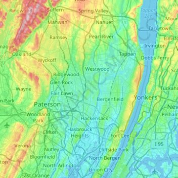
Name: Bergen County topographic map, elevation, terrain.
Location: Bergen County, New Jersey, United States (40.76203 -74.27248 41.13447 -73.89363)
Average elevation: 66 m
Minimum elevation: -4 m
Maximum elevation: 347 m
Other topographic maps
Click on a map to view its topography, its elevation and its terrain.
Rancocas Woods
United States > New Jersey > Burlington County > Mount Laurel Township
Average elevation: 12 m
Sandy Hook Lighthouse
United States > New Jersey > Monmouth County > Middletown Township > Fort Hancock
Average elevation: 1 m
Ellisdale
United States > New Jersey > Monmouth County > Upper Freehold Township
Average elevation: 34 m
Hilton
United States > New Jersey > Monmouth County > Atlantic Highlands
Atlantic Highlands has a humid subtropical climate (Cfa) and average monthly temperatures range from 32.6 °F (0.3 °C) in January to 75.9 °F (24.4 °C) in July. The hardiness zone is 7a or 7b depending upon elevation.
Average elevation: 17 m
Communipaw
United States > New Jersey > Hudson County > Jersey City > Communipaw
Average elevation: 8 m