
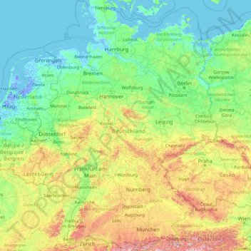
Germany topographic map
Interactive map
Click on the map to display elevation.
About this map
Name: Germany topographic map, elevation, terrain.
Location: Germany (47.27011 5.86632 55.09916 15.04193)
Average elevation: 237 m
Minimum elevation: -7 m
Maximum elevation: 2,744 m
Elevation ranges from the mountains of the Alps (highest point: the Zugspitze at 2,963 metres or 9,721 feet) in the south to the shores of the North Sea (Nordsee) in the northwest and the Baltic Sea (Ostsee) in the northeast. The forested uplands of central Germany and the lowlands of northern Germany (lowest point: in the municipality Neuendorf-Sachsenbande, Wilstermarsch at 3.54 metres or 11.6 feet below sea level) are traversed by such major rivers as the Rhine, Danube and Elbe. Significant natural resources include iron ore, coal, potash, timber, lignite, uranium, copper, natural gas, salt, and nickel.
Other topographic maps
Click on a map to view its topography, its elevation and its terrain.
India
India
Average elevation: 1,017 m
Montreal
Canada > Quebec > Urban agglomeration of Montreal > Montreal
Montreal, Urban agglomeration of Montreal, Montreal (06), Quebec, H3B 1M7, Canada
Average elevation: 30 m
Hyderabad
India > Telangana > Bahadurpura mandal
Hyderabad, Bahadurpura mandal, Hyderabad District, Telangana, India
Average elevation: 549 m
Snohomish County
Snohomish County, Washington, United States
Average elevation: 649 m
Pune
India > Maharashtra > Pune City > Pune
Pune, Pune City, Pune District, Maharashtra, 411001, India
Average elevation: 641 m
Chennai
India > Tamil Nadu > Chennai
Chennai, Chennai District, Tamil Nadu, India
Average elevation: 8 m
Tacoma
United States > Washington > Pierce County
Tacoma, Pierce County, Washington, United States
Average elevation: 67 m
Ocheretyne
Ocheretyne, Ocheretyne settlement hromada, Pokrovskii Raion, Donetsk Oblast, 86020, Ukraine
Average elevation: 227 m
Sri Lanka
Sri Lanka
Average elevation: 50 m
Oddapalem
India > Andhra Pradesh > Muthukur > Oddapalem
Oddapalem, Muthukur, Sri Potti Sriramulu Nellore, Andhra Pradesh, 524346, India
Average elevation: 8 m
Saadiyat Island
United Arab Emirates > Abu Dhabi Emirate > Abu Dhabi > Abu Dhabi
Saadiyat Island, Abu Dhabi, Abu Dhabi Emirate, United Arab Emirates
Average elevation: 1 m
gehunlad
India > Uttarakhand > Chaubatta Khal
gehunlad, Chaubatta Khal, Pauri Garhwal District, Uttarakhand, India
Average elevation: 1,625 m
Tigania Beach
Greece > Macedonia and Thrace > Chalkidiki Regional Unit > Toroni Municipal Unit
Tigania Beach, Toroni Municipal Unit, Municipality of Sithonia, Chalkidiki Regional Unit, Central Macedonia, Macedonia and Thrace, Greece
Average elevation: 11 m
Hubli
India > Karnataka > Hubballi Urban Taluku
Hubli, Hubballi Urban Taluku, Dharwad District, Karnataka, 580020, India
Average elevation: 626 m
Mangaluru
India > Karnataka > Mangaluru taluk
Mangaluru, Mangaluru taluk, Dakshina Kannada District, Karnataka, 575001, India
Average elevation: 25 m
Thanjavur
India > Tamil Nadu > Thanjavur
Thanjavur, Thanjavur District, Tamil Nadu, 613001, India
Average elevation: 49 m
Anaikatti
India > Tamil Nadu > Coimbatore North
Anaikatti, Mannarkad, Palakkad District, Kerala, 678741, India
Average elevation: 623 m
Samethanahalli
India > Karnataka > Hosakote taluk
Samethanahalli, Hosakote taluk, Bengaluru Rural, Karnataka, 560117, India
Average elevation: 868 m
Delhi
India > Delhi > Kotwali Tehsil
Delhi, Kotwali Tehsil, Central Delhi, Delhi, 110006, India
Average elevation: 216 m
Clappana
India > Kerala > Karunagappally
Clappana, Karunagappally, Kollam District, Kerala, 690525, India
Average elevation: 5 m
Kandy
Kandy, Kandy District, Central Province, 20000, Sri Lanka
Average elevation: 621 m
Siliguri
India > West Bengal > Siliguri Subdivsion
Siliguri, Siliguri Subdivsion, Darjeeling District, West Bengal, India
Average elevation: 121 m
Surat
India > Gujarat > Katargam Taluka > Surat
Surat, Katargam Taluka, Surat, Gujarat, 395001, India
Average elevation: 11 m
Bengaluru
India > Karnataka > Bangalore North
Bengaluru, Bangalore North, Bengaluru Urban District, Karnataka, India
Average elevation: 881 m
Naula
India > Uttarakhand > Bhanoli
Naula, Bhanoli, Almora District, Uttarakhand, India
Average elevation: 1,562 m
Rajmachi Fort
India > Maharashtra > Mawal > Udhewadi
Rajmachi Fort, Udhewadi, Mawal, Pune District, Maharashtra, India
Average elevation: 501 m
Visapur Fort
India > Maharashtra > Mawal > Patan
Visapur Fort, Bhatrishi peak, Patan, Mawal, Pune District, Maharashtra, 410401, India
Average elevation: 818 m
Dadholi
India > Uttarakhand > Dwarahat
Dadholi, Dwarahat, Almora District, Uttarakhand, 263654, India
Average elevation: 1,449 m
Shakarpur
India > Delhi > Gandhi Nagar Tehsil
Shakarpur, Gandhi Nagar Tehsil, East Delhi District, Delhi, India
Average elevation: 206 m
Dudori
India > Uttarakhand > Syalde > Kaljipa
Dudori, Kaljipa, Syalde, Almora District, Uttarakhand, 263665, India
Average elevation: 1,564 m
Vairavanpatti
India > Tamil Nadu > Thiruppathur
Vairavanpatti, Thiruppathur, Sivagangai District, Tamil Nadu, 630207, India
Average elevation: 103 m
Dahej
India > Gujarat > Vagra Taluka
Dahej, Vagra Taluka, Bharuch District, Gujarat, 393125, India
Average elevation: 6 m
Warud
India > Maharashtra > Buldhana
Warud, Buldhana, Buldhana District, Maharashtra, India
Average elevation: 594 m
Badroud
Iran > Isfahan Province > Natanz County
Badroud, بخش امامزاده, Natanz County, Isfahan Province, 87661-37751, Iran
Average elevation: 994 m
Pura
Indonesia > East Nusa Tenggara > Alor
Pura, Alor, East Nusa Tenggara, Lesser Sunda Islands, Indonesia
Average elevation: 275 m
Malhargad Fort
India > Maharashtra > Purandhar
Malhargad Fort, Malhargad Walking Path, Purandhar, Pune District, Maharashtra, India
Average elevation: 822 m
Torna Fort
India > Maharashtra > Velhe
Torna Fort, Rajgad - Torna trail, Velhe, Pune District, Maharashtra, 412212, India
Average elevation: 1,013 m
Gladstone Regional
Gladstone Regional, Queensland, Australia
Average elevation: 116 m