
Batticaloa District topographic map
Interactive map
Click on the map to display elevation.
About this map
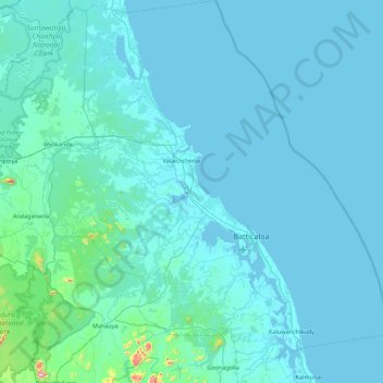
Name: Batticaloa District topographic map, elevation, terrain.
Location: Batticaloa District, Eastern Province, Sri Lanka (7.39870 81.22496 8.27600 82.01529)
Average elevation: 27 m
Minimum elevation: -3 m
Maximum elevation: 670 m
Other topographic maps
Click on a map to view its topography, its elevation and its terrain.
Batticaloa
Sri Lanka > Eastern Province > Manmunai North DS Division
Batticaloa is in the eastern coast of Sri Lanka on a flat coastal plain boarded by the Indian Ocean in the east occupies a central part of the eastern Sri Lanka. Its average elevation is around 5 meters. Batticaloa district has three lagoons such as Batticaloa Lagoon, Valaichchenai Lagoon, and Vakari…
Average elevation: 5 m