
Thambiluvil topographic map
Interactive map
Click on the map to display elevation.
About this map
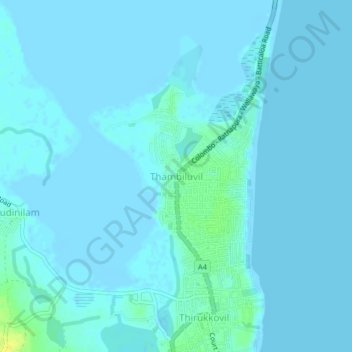
Name: Thambiluvil topographic map, elevation, terrain.
Location: Thambiluvil, Ampara District, Eastern Province, 32415, Sri Lanka (7.11161 81.82853 7.15161 81.86853)
Average elevation: 2 m
Minimum elevation: -3 m
Maximum elevation: 19 m
Other topographic maps
Click on a map to view its topography, its elevation and its terrain.