
Make a donation
Ladakh topographic map
Click on the map to display elevation.
Make a donation
Ladakh
The Kargil War of 1999, codenamed "Operation Vijay" by the Indian Army, saw infiltration by Pakistani troops into parts of Western Ladakh, namely Kargil, Dras, Mushkoh, Batalik and Chorbatla, overlooking key locations on the Srinagar-Leh highway. Extensive operations were launched in high altitudes by the Indian Army with considerable artillery and air force support. Pakistani troops were evicted from the Indian side of the Line of Control which the Indian government ordered was to be respected and which was not crossed by Indian troops. The Indian government was criticised by the Indian public because India respected geographical co-ordinates more than India's opponents: Pakistan and China.
Make a donation
About this map
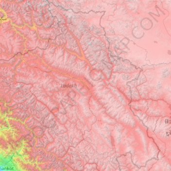
Name: Ladakh topographic map, elevation, terrain.
Location: Ladakh, India (32.33574 75.32697 35.67293 79.46073)
Average elevation: 4,726 m
Minimum elevation: 337 m
Maximum elevation: 7,470 m
Make a donation
Other topographic maps
Click on a map to view its topography, its elevation and its terrain.
Maharashtra
Maharashtra is the third largest state by area in India. The Western Ghats better known as Sahyadri, are a hilly range running parallel to the coast, at an average elevation of 1,200 metres (4,000 ft). Kalsubai, a peak in the Sahyadris, near Nashik city is the highest elevated point in Maharashtra. To the west…
Average elevation: 478 m
Cuttack
India > Odisha > Cuttack (M.Corp.) P.S
Cuttack is located at 20°31′23″N 085°47′17″E / 20.52306°N 85.78806°E / 20.52306; 85.78806 and has an average elevation of 36 metres (118 ft). The city is spread across an area of 192.5 km2 (74 sq mi). The city, being a Cuttack Municipal Corporation which consists of 59 wards. The city…
Average elevation: 34 m
Make a donation
Kodaikanal
India > Tamil Nadu > Kodaikanal
Kodaikanal has a monsoon-influenced subtropical highland climate (Cfb, according to the Köppen climate classification, with a Cwb tendency). The temperatures are cool throughout the year due to the high elevation of the city.
Average elevation: 1,958 m
Make a donation
Thiruvananthapuram
India > Kerala > Thiruvananthapuram
Thiruvananthapuram is built on seven hills by the seashore and is at 8°30′N 76°54′E / 8.5°N 76.9°E / 8.5; 76.9 on the west coast, near the southern tip of mainland India. The city is on the west coast of India and is bounded by the Laccadive Sea to its west and the Western Ghats to its east.…
Average elevation: 33 m
Lucknow
India > Uttar Pradesh > Lucknow
Lucknow stands at an elevation of approximately 123 metres (404 ft) above sea level. The city had an area of 402 km2 (155 square miles) until December 2019, when 88 villages were added to the municipal limits and the area increased to 631 km2 (244 square miles). Bounded on the east by Barabanki, on the west by…
Average elevation: 120 m
Make a donation
Dharamshala
India > Himachal Pradesh > Dharamshala
Dharamshala has an average elevation of 1,457 m (4,780 ft), covering an area of almost 8.51 km2 (3.29 sq mi). Dharamsala is located in the Kangra Valley, in the shadow of the Dhauladhar mountains.
Average elevation: 1,781 m
Lonavala
India > Maharashtra > Mawal
Adjacent to the Lohagad fort lies the visapur fort which is part of the Lohagad-Visapur fortification. Visapur Fort is larger and at a higher elevation than its twin- Lohagad. It was built during 1713-1720 CE by Balaji Vishwanath.
Average elevation: 613 m
Mumbai
Mumbai lies at the mouth of the Ulhas River on the western coast of India, in the coastal region known as the Konkan. It sits on Salsette Island (Sashti Island), which it partially shares with the Thane district. Mumbai is bounded by the Arabian Sea to the west. Many parts of the city lie just above sea level,…
Average elevation: 13 m
Make a donation
Leh
Leh (/ˈlɛ/) (Ladakhi: གླེ) is the joint capital and largest city of Ladakh, a union territory of India. Leh, located in the Leh district, was also the historical capital of the Kingdom of Ladakh, the seat of which was in the Leh Palace, the former residence of the royal family of Ladakh, built in the…
Average elevation: 4,294 m
Vadodara
India > Gujarat > Vadodara Rural Taluka
Vadodara is located at 22°18′N 73°11′E / 22.30°N 73.19°E / 22.30; 73.19 in western India at an elevation of 39 metres (128 ft). It is the tenth-largest city in India with an area of 400 square kilometres (150 sq mi) and a population of 3.5 million, according to the 2010–11 census. The city…
Average elevation: 36 m
Dehradun
India > Uttarakhand > Dehradun
The city of Dehradun mainly lies in Doon Valley and is at a varying height from 410 m (1,350 ft) in Clement Town to above 700 m (2,300 ft) at Malsi which is 15 km (9.3 mi) from the city. However, the average elevation is 450 m (1,480 ft) above sea level. Malsi is the starting point of Lesser Himalayan Range…
Average elevation: 904 m
Make a donation
Rajpur Sonarpur
India > West Bengal > Sonarpur
Rajpur Sonarpur is located at 22°26′18″N 88°25′55″E / 22.4382026°N 88.4320450°E / 22.4382026; 88.4320450. It has an average elevation of 9 metres (30 ft).
Average elevation: 4 m
Make a donation
Kalasubai peak
India > Maharashtra > Akola > Karanda
Kalsubai (Marathi: कळसूबाई शिखर) is a mountain in the Western Ghats, located in the Indian state of Maharashtra. Its summit, situated at an elevation of 1,646 metres (5,400 ft), is the highest point in Maharashtra.
Average elevation: 1,210 m
Make a donation
Mysuru
India > Karnataka > Mysuru taluk
Mysore (/maɪˈsɔːr/ (listen)), officially Mysuru ([ˈmaɪˈsuːɾu] (listen)), is a city in the southern part of the state of Karnataka, India. Mysore city is geographically located between 12° 18′ 26″ north latitude and 76° 38′ 59″ east longitude. It is located at an altitude of 770 m (2,530 ft)…
Average elevation: 727 m
Lachung
India > Sikkim > Chungthang
Lachung is a town and hill station in Mangan district in northeast Indian state of Sikkim. It is approx. 50 km Mangan town, the district headquarters. It is located in the Mangan district near the border with Tibet. Lachung is at an elevation of about 9,600 feet (2,900 m) and at the confluence of the Lachen…
Average elevation: 3,617 m
Make a donation
Siliguri
India > West Bengal > Matigara block
Siliguri located at the foothills of the eastern Himalayas at a location of 26°43′N 88°26′E / 26.71°N 88.43°E / 26.71; 88.43. This city is spread over an area of 260 km2 within the Siliguri Corridor, also known as the Chicken's neck. The city is surrounded by dense forests towards north and…
Average elevation: 121 m
Guwahati
Professor Abani Kumar Bhagawati of Gauhati University stated that since before there were sufficient wetlands to absorb rainwater and channels to carry excess water to the Brahmaputra, the city did not experience floods. However, human interference has disrupted the natural topography, leading to the current…
Average elevation: 113 m
Make a donation
Kolkata
Spread roughly north–south along the east bank of the Hooghly River, Kolkata sits within the lower Ganges Delta of eastern India approximately 75 km (47 mi) west of the international border with Bangladesh; the city's elevation is 1.5–9 m (5–30 ft). Much of the city was originally a wetland that was…
Average elevation: 5 m
Make a donation
Make a donation
Make a donation
Lakhimpur
India > Uttar Pradesh > Lakhimpur
Lakhimpur is located at 27°57′N 80°46′E / 27.95°N 80.77°E / 27.95; 80.77. It has an average elevation of 147 metres (482 ft).
Average elevation: 141 m
Make a donation
Make a donation
Chennai
Chennai is located on the south–eastern coast of India in the north–eastern part of Tamil Nadu on a flat coastal plain known as the Eastern Coastal Plains. Its average elevation is around 6.7 metres (22 ft), and its highest point is 60 m (200 ft). Chennai is 2,184 kilometres (1,357 mi) south of Delhi,…
Average elevation: 7 m
Vagamon
Vagamon, due to its elevation and climate, has a unique ecosystem, leading to the emergence of rich natural vegetation, plant species, shola forests etc. From the early 20th century plantation crops like tea, coffee started. Vagamon hills are home to less explored flora and fauna. A faunal diversity study…
Average elevation: 866 m
Make a donation
Patna
India > Bihar > Patna Rural
Patna is on the southern bank of the river Ganges. The total area of Patna is 250 km2 (97 sq mi). Of this, the municipal area constitutes 109.218 km2 (42.169 sq mi). The suburban area covers 140.782 km2 (54.356 sq mi). It has an average elevation of 53 m (174 ft). A characteristic feature of the geography of…
Average elevation: 51 m
Nelamangala
India > Karnataka > Nelamangala taluk
{{Infobox settlement | name = Nelamangala | native_name = ನೆಲಮಂಗಲ | native_name_lang = kn | other_name = | nickname = | settlement_type = City | image_skyline = | image_alt = | image_caption = | pushpin_map = India Karnataka#India#Asia | pushpin_label_position = right | pushpin_map_alt = |…
Average elevation: 884 m
Thanjavur
India > Tamil Nadu > Thanjavur
Thanjavur is located at 10°48′N 79°09′E / 10.8°N 79.15°E / 10.8; 79.15 The tributaries of river Cauvery, namely, the Grand Anaicut canal (Pudhaaru), Vadavaaru and Vennaaru rivers flow through the city. Thanjavur is situated in the Cauvery delta, at a distance of 314 km (195 mi) south-west of…
Average elevation: 49 m
Make a donation
Make a donation
Karnaprayag
India > Uttarakhand > Karnaprayag
Karnaprayag is located at 30°16′N 79°15′E / 30.27°N 79.25°E / 30.27; 79.25. It has an average elevation of 860 metres (2,820 feet). The confluence of the Pindar River, which arises from the icy Pindari glacier and the Alaknanda, occurs at Karnaprayag.
Average elevation: 1,273 m
Make a donation
Matheran
India > Maharashtra > Karjat Taluka
Matheran is an automobile-free hill station and a municipal council in the Karjat taluka of the Raigad district located in the Indian state of Maharashtra. Matheran is part of the Mumbai Metropolitan Region, and one of the smallest hill stations in India. It is located in the Western Ghats, at an elevation of…
Average elevation: 325 m
Ambaji
India > Gujarat > Danta Taluka
Ambaji is a town within taluka district Banaskantha, North Gujarat, India. It is located at 24°20′N 72°51′E / 24.33°N 72.85°E / 24.33; 72.85. It is at an altitude of 480 metres (1,570 ft). It is surrounded by the Araveli Hill range. Ambaji is within the Aravali Range'line of peaks', is a range…
Average elevation: 453 m
Make a donation
Make a donation
Western Ghats
The range starts near south of the Tapti river and runs approximately 1,600 km (990 mi) through the states of Gujarat, Maharashtra, Karnataka, Goa, Kerala and Tamil Nadu ending at Marunthuvazh Malai, Swamithope near the southern tip of India. These hills cover 160,000 km2 (62,000 sq mi) and form the catchment…
Average elevation: 2,225 m
Make a donation
Mussoorie
India > Uttarakhand > Dehradun
Mussoorie is at an average altitude of 2,005 metres (6,578 ft). To the northeast are the Himalayan snow ranges, and to the south, the Doon Valley and Shiwalik ranges. The second highest point is the original Lal Tibba in Landour, with a height of over 2,275 m (7,464 ft). Mussoorie is popularly known as The…
Average elevation: 1,594 m
Srinagar
India > Jammu and Kashmir > Srinagar (South)
Under the Köppen climate classification, Srinagar has a four-season humid subtropical climate (Cfa) with hot summers and cool winters. The valley is surrounded by the Himalayas on all sides. Due to influence from Himalayan rain shadow and western disturbances, Srinagar has year-round precipitation; the spring…
Average elevation: 1,805 m
Make a donation
Rajamahendravaram
India > Andhra Pradesh > Rajahmundry (Urban)
Rajahmundry is located at 16°59′N 81°47′E / 16.98°N 81.78°E / 16.98; 81.78. with an average elevation of 14 metres (46 ft). It is geographically located at centre of Godavari Districts.There is paddy, sugarcane and various varieties of flowers cultivation in the area. River Godavari flows…
Average elevation: 29 m
Make a donation
Ujjain
India > Madhya Pradesh > Ujjain NagarTahsil
Ujjain is located in the west-central part of India, and is north of the upper limit of the Vindhya mountain ranges. Located on the Malwa plateau, it is higher than the north Indian plains and the land rises towards the Vindhya Range to the south. Ujjain's co-ordinates are 23°10′N 75°46′E /…
Average elevation: 501 m
Bhopal
India > Madhya Pradesh > Huzur Tahsil
Bhopal has an average elevation of 500 metres (1401 ft) and is located in the central part of India, just north of the upper limit of the Vindhya mountain ranges. Located on the Malwa plateau, it is higher than the north Indian plains and the land rises towards the Vindhya Range to the south. The city has…
Average elevation: 498 m
Make a donation
Salem
Salem is located at 11°40′N 78°08′E / 11.67°N 78.14°E / 11.67; 78.14, at an average elevation of 278 m (912 ft). The city is surrounded by hills: Nagaramalai on the north, Jarugumalai on the south, Kanjamalai on the west, Godumalai on the east and the Shevaroy Hills on the northeast.…
Average elevation: 418 m
Make a donation