
Make a donation
Khao Phra Ngam topographic map
Click on the map to display elevation.
Make a donation
About this map
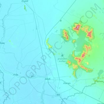
Name: Khao Phra Ngam topographic map, elevation, terrain.
Location: Khao Phra Ngam, Lop Buri Province, Thailand (14.72547 100.46918 15.04547 100.78918)
Average elevation: 41 m
Minimum elevation: 5 m
Maximum elevation: 620 m
Make a donation
Other topographic maps
Click on a map to view its topography, its elevation and its terrain.
Kanchanaburi Province
The province is in the west of Thailand, 129 km from Bangkok, and covers a total area of approximately 19,483 km2 (7,522 sq mi). It is the country's third largest province, after Nakhon Ratchasima and Chiang Mai. Topographically, it is covered with timber and evergreen forests. The total forest area is 12,002…
Average elevation: 297 m
Make a donation
Songkhla Province
The province is on the Malay Peninsula, on the coast of the Gulf of Thailand. The highest elevation is Khao Mai Kaeo at 821 meters.
Average elevation: 56 m
Make a donation
Ko Pha Ngan
Thailand > Surat Thani Province
Due to its topography, the population hugs the coastline. The mountainous interior is generally inaccessible. More than half the island designated as national park and Ko Pha-ngan has more than 80 km2 (31 sq mi) of relatively unspoiled rain forest with diverse flora and fauna. It is also considered a spiritual…
Average elevation: 84 m
Make a donation
Make a donation
Chiang Mai Province
Chiang Mai province is about 685 km (426 mi) from Bangkok in the Mae Ping River basin and is on average at 300 m (1,000 ft) elevation. Surrounded by the mountain ranges of the Thai highlands, it covers an area of approximately 22,135 km2 (9,000 sq mi). The mountains of the Daen Lao Range…
Average elevation: 649 m
Make a donation
Chanthaburi Province
While the southern part of the province is on the shore of the Gulf of Thailand and thus is mostly coastal alluvial plains, the interior of the province is mountainous. The Chanthaburi Mountains in the north has the highest elevation in the province, the 1,675 m high Khao Soi Dao Tai peak. The main river of…
Average elevation: 96 m
Make a donation
Prachuap Khiri Khan Province
Prachuap Khiri Khan covers an area totaling 6,367 square kilometers (2,458 sq mi). The province is on the Kra Isthmus, the narrow land bridge connecting the Malay Peninsula with mainland Asia. The province has the narrowest part of Thailand, just 12.38 km (7.69 mi) from the Gulf of Thailand to the border with…
Average elevation: 105 m
Make a donation
Chaiyaphum Province
The province is bisected by the Phetchabun mountain range, with the highest elevation in the province at 1,222 m. The east of the province is part of the Khorat Plateau. The total forest area is 3,982 km2 (1,537 sq mi) or 31.4 percent of provincial area.
Average elevation: 317 m
Make a donation
Kalasin Province
Most of the province is covered by a hilly landscape. The town of Kalasin is at an elevation of 152 m (499 ft). In the north is the Lam Pao Dam built from 1963 to 1968. It stores 1,430 million m3 of water for flood prevention and agriculture. The Lam Pao reservoir effectively cuts the northern part of the…
Average elevation: 200 m
Make a donation
Make a donation
Make a donation
Ratchaburi Province
The area of Ratchaburi Province is divided into three parts. First, the border in the west which is shared with Myanmar and is about 60 kilometres (37 mi) long. The second contains the Tenasserim mountains and forests with an elevation of about 200–300 meters. The central area of the province is rich in…
Average elevation: 275 m
Make a donation
Maha Phram Subdistrict Municipality
Thailand > Phra Nakhon Si Ayutthaya Province > Bang Ban District
Average elevation: 5 m
Make a donation
Make a donation
Make a donation
Make a donation
Mae Hong Son Province
The Daen Lao Range, in the northernmost portion of the province, marks the northern boundary between Thailand and Burma, while the Dawna Range in the west serves as the boundary between Thailand and Burma. The Thanon Thongchai Range in the east of the province serves as the boundary between the provinces of…
Average elevation: 704 m
Make a donation
Chachoengsao Province
The western part of the province is the low river plain of the Bang Pa Kong River, which is used extensively for farming rice. To the east is hillier terrain, with an average elevation of more than 100 metres. In Tha Takiap District is the Khao Ang Rue Nai Wildlife Sanctuary with an area of 674,352 rai ~ 1,078…
Average elevation: 70 m
Nakhon Nayok Province
The northern part of the province is in the Sankamphaeng Range, the southern prolongation of the Dong Phaya Yen Mountains, with the highest elevation the 1,292-meter-high Yod Khao Kiew. Most of that area is covered by the Khao Yai National Park, 2,166 km2 (836 sq mi), along with three other national parks,…
Average elevation: 183 m