
Make a donation
Phayao Province topographic map
Click on the map to display elevation.
Make a donation
About this map
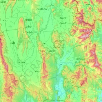
Name: Phayao Province topographic map, elevation, terrain.
Location: Phayao Province, Thailand (18.80660 99.68719 19.73551 100.63416)
Average elevation: 551 m
Minimum elevation: 242 m
Maximum elevation: 1,735 m
Make a donation
Other topographic maps
Click on a map to view its topography, its elevation and its terrain.
Chiang Mai
The city is situated in a valley on a river basin in the Thai highlands and is on average at 300 m (1,000 ft) elevation. Chiang Mai's city centre sits west of the Ping River, a tributary to the Chao Phraya River, while the city's sprawl extends north-west, south-west, north-east and east of the river. To the…
Average elevation: 424 m
Make a donation
Make a donation
Make a donation
Ban Ton Pho
Thailand > Pathum Thani Province > Suan Phrik Thai Subdistrict Administrative Organization > Suan Phrik Thai Subdistrict
Average elevation: 4 m
Make a donation
Ban Yai Ka Ta
Thailand > Phra Nakhon Si Ayutthaya Province > Uthai Subdistrict Administrative Organization > Uthai Subdistrict
Average elevation: 4 m
Make a donation
Bangkok
Bangkok is situated in the Chao Phraya River delta in Thailand's central plain. The river meanders through the city in a southerly direction, emptying into the Gulf of Thailand approximately 25 kilometres (16 mi) south of city centre. The area is flat and low-lying, with an average elevation of 1.5 metres (4…
Average elevation: 4 m
Make a donation
Ban Lak Khon Nuea
Thailand > Nonthaburi Province > Bang Bua Thong District > Lam Pho Subdistrict > Ban Lak Khon Nuea
Average elevation: 3 m
Make a donation
Make a donation
Make a donation