
Ko Pha Ngan topographic map
Interactive map
Click on the map to display elevation.
Ko Pha Ngan
Due to its topography, the population hugs the coastline. The mountainous interior is generally inaccessible. More than half the island designated as national park and Ko Pha-ngan has more than 80 km2 (31 sq mi) of relatively unspoiled rain forest with diverse flora and fauna. It is also considered a spiritual place, with numerous Buddhist temples around the island and a thriving spa, retreat, and meditation industry.
About this map
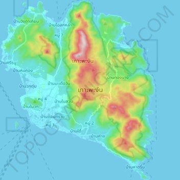
Name: Ko Pha Ngan topographic map, elevation, terrain.
Location: Ko Pha Ngan, Surat Thani Province, Thailand (9.66567 99.96074 9.80402 100.08177)
Average elevation: 84 m
Minimum elevation: 0 m
Maximum elevation: 602 m
Other topographic maps
Click on a map to view its topography, its elevation and its terrain.