
Thank you for supporting this site ❤️
Make a donation
Make a donation
Tapi River topographic map
Click on the map to display elevation.
Thank you for supporting this site ❤️
Make a donation
Make a donation
About this map
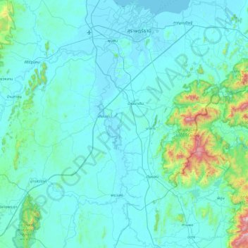
Name: Tapi River topographic map, elevation, terrain.
Location: Tapi River, Surat Thani Province, Thailand (8.38723 99.17720 9.24458 99.74171)
Average elevation: 123 m
Minimum elevation: 0 m
Maximum elevation: 1,621 m
Thank you for supporting this site ❤️
Make a donation
Make a donation
Other topographic maps
Click on a map to view its topography, its elevation and its terrain.