
Make a donation
Mae Hong Son Province topographic map
Click on the map to display elevation.
Make a donation
Mae Hong Son Province
The Daen Lao Range, in the northernmost portion of the province, marks the northern boundary between Thailand and Burma, while the Dawna Range in the west serves as the boundary between Thailand and Burma. The Thanon Thongchai Range in the east of the province serves as the boundary between the provinces of Mae Hong Son and Chiang Mai. The highest point of the province is Doi Mae Ya (ยอดเขาแม่ยะ), in the Pai District in the province's northeast, at 2,005 metres (6,578 ft) elevation.
Make a donation
About this map
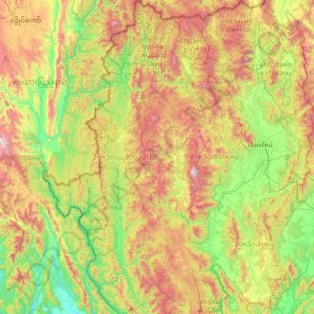
Name: Mae Hong Son Province topographic map, elevation, terrain.
Location: Mae Hong Son Province, Thailand (17.56653 97.34381 19.81427 98.65251)
Average elevation: 704 m
Minimum elevation: 26 m
Maximum elevation: 2,546 m
Make a donation
Other topographic maps
Click on a map to view its topography, its elevation and its terrain.
Chiang Mai
The city is situated in a valley on a river basin in the Thai highlands and is on average at 300 m (1,000 ft) elevation. Chiang Mai's city centre sits west of the Ping River, a tributary to the Chao Phraya River, while the city's sprawl extends north-west, south-west, north-east and east of the river. To the…
Average elevation: 424 m
Make a donation
Make a donation
Make a donation
Ban Ton Pho
Thailand > Pathum Thani Province > Suan Phrik Thai Subdistrict Administrative Organization > Suan Phrik Thai Subdistrict
Average elevation: 4 m
Make a donation
Ban Yai Ka Ta
Thailand > Phra Nakhon Si Ayutthaya Province > Uthai Subdistrict Administrative Organization > Uthai Subdistrict
Average elevation: 4 m
Make a donation
Bangkok
Bangkok is situated in the Chao Phraya River delta in Thailand's central plain. The river meanders through the city in a southerly direction, emptying into the Gulf of Thailand approximately 25 kilometres (16 mi) south of city centre. The area is flat and low-lying, with an average elevation of 1.5 metres (4…
Average elevation: 4 m
Make a donation
Ban Lak Khon Nuea
Thailand > Nonthaburi Province > Bang Bua Thong District > Lam Pho Subdistrict > Ban Lak Khon Nuea
Average elevation: 3 m
Make a donation
Make a donation
Make a donation