Geolocate

Gawan topographic map

Interactive map

Click on the map to display elevation.

About this map

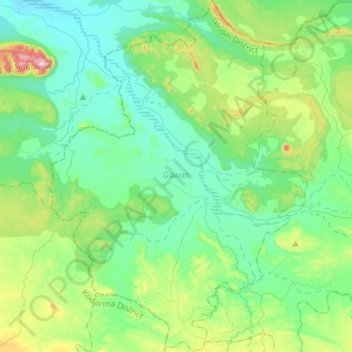
Name: Gawan topographic map, elevation, terrain.

Location: Gawan, Giridih District, Jharkhand, 825132, India (24.50541 85.77194 24.76490 85.98124)

Average elevation: 245 m

Minimum elevation: 127 m

Maximum elevation: 657 m

Other topographic maps

Click on a map to view its topography, its elevation and its terrain.

Ranchi

India > Jharkhand > Kanke

Ranchi lies at 23°22′N 85°20′E / 23.36°N 85.33°E / 23.36; 85.33 near to the Tropic of Cancer. The city covers an area of 175 km2 (68 sq mi) and its average elevation is 651 m above sea level. Ranchi is located in the southern part of the Chota Nagpur plateau, which is the eastern section of…

Average elevation: 648 m

Mahudand

India > Jharkhand > Hussainabad

Average elevation: 275 m

Usri Nadi

India > Jharkhand > Giridih

Average elevation: 275 m

Hundrughagh Falls

India > Jharkhand > Angara

Average elevation: 428 m

Sindri

India > Jharkhand > Baliapur

Average elevation: 160 m

Maluti

India > Jharkhand > Shikaripara

Average elevation: 56 m

Rajmahal

India > Jharkhand > Rajmahal

Average elevation: 26 m

Trikut Hill

India > Jharkhand > Mohanpur > Mohanpur

Average elevation: 363 m

Chichi

India > Jharkhand > Katamdag

Average elevation: 621 m

Chitarpur

India > Jharkhand > Chitarpur

Chitarpur is located at 23°34′30″N 85°39′17″E / 23.5749°N 85.6548°E / 23.5749; 85.6548. It has an average elevation of 364 metres (1167 feet).

Average elevation: 344 m

Kalapathar

India > Jharkhand > Saraikela

Average elevation: 174 m

Dhanbad

India > Jharkhand > Dhanbad-Cum-Kenduadih-Cum-Jagata

Dhanbad has an average elevation of 227 m (745 ft). Its geographical length (extending from north to south) is 15 miles (24 km) and the breadth (stretching across east to West) is 10 miles (16 km). It shares its boundaries with West Bengal in the eastern and southern part, Giridih and Dumka in the North and…

Average elevation: 212 m

Sindri

India > Jharkhand > Baliapur

Average elevation: 160 m

Katikund

India > Jharkhand > Kathikund

Average elevation: 161 m

Danwar

India > Jharkhand > Dhanwar

Average elevation: 351 m

Pithoria

India > Jharkhand > Kanke

Average elevation: 657 m

Okhargara

India > Jharkhand > Meral (Pipra Kalan)

Average elevation: 226 m

Jamshedpur

India > Jharkhand > Golmuri-Cum-Jugsalai

Jamshedpur is situated in the southern end of the state of Jharkhand and is bordered by the states of Odisha and West Bengal. The average elevation of the city is 135 metres while the range is from 129 m to 151 m. Total geographical area of Jamshedpur is 224 km square. Jamshedpur is primarily located in a…

Average elevation: 195 m

Ramgarh

India > Jharkhand > Ramgarh

Average elevation: 346 m

Gomoh

India > Jharkhand > Topchanchi

Gomoh is located at 23°52′N 86°10′E / 23.87°N 86.17°E / 23.87; 86.17. It has an average elevation of 245 metres (803 feet). The town has an area of 8.96 km2. It is 37 km from the district administrative headquarters in Dhanbad.

Average elevation: 248 m

Jaduguda

India > Jharkhand > Musabani

Average elevation: 148 m

Rohinibera

India > Jharkhand > Potka

Average elevation: 206 m

Baharagora

India > Jharkhand > Baharagora

Baharagora is located at 22°17′N 86°43′E / 22.28°N 86.72°E / 22.28; 86.72. It has an average elevation of 79 m (259 ft). The Subarnarekha River flows along its adjoining areas (approx at a distance of 7 km [4.3 mi]).

Average elevation: 76 m

Chakulia

India > Jharkhand > Chandil

Average elevation: 186 m

Phusro

India > Jharkhand > Bermo

Bokaro district consists of undulating uplands on the Chota Nagpur Plateau with the Damodar River cutting a valley right across. It has an average elevation of 200 to 540 metres (660 to 1,770 ft) above mean sea level. The highest hill, Lugu Pahar, rises to a height of 1,070 metres (3,510 ft). The East Bokaro…

Average elevation: 223 m

Doranda

India > Jharkhand > Bero

Average elevation: 695 m

Jamshedpur

India > Jharkhand > Golmuri-Cum-Jugsalai

Jamshedpur is situated at the southern end of the state of Jharkhand and is bordered by the states of Odisha and West Bengal. The average elevation of the city is 135 metres while the range is from 129 m to 151 m. Total geographical area of Jamshedpur is 224 km square. Jamshedpur is primarily located in a…

Average elevation: 195 m

Haidarnagar

India > Jharkhand > Haidernagar

Average elevation: 150 m

By Pass

India > Jharkhand > Keredari

Average elevation: 452 m

Dhanbad

India > Jharkhand > Dhanbad-Cum-Kenduadih-Cum-Jagata

Dhanbad has an average elevation of 227 m (745 ft). Its geographical length (extending from north to south) is 15 miles (24 km) and the breadth (stretching across east to West) is 10 miles (16 km). It shares its boundaries with West Bengal in the eastern and southern part, Dumka and Giridih in the North and…

Average elevation: 212 m

North Koel River

India > Jharkhand > Chainpur

Average elevation: 206 m

Rajdah

India > Jharkhand > Potka

Average elevation: 166 m

Rajrappa

India > Jharkhand > Chitarpur

Average elevation: 299 m

Sahibganj

India > Jharkhand > Sahibganj (block)

Average elevation: 73 m

Bokaro

India > Jharkhand > Chas

Bokaro district consists of undulating uplands on the Chota Nagpur Plateau with the Damodar River cutting a valley right across. It has an average elevation of 200 to 540 metres (660 to 1,770 ft) above mean sea level. The highest hill, Lugu Pahar, rises to a height of 1,070 metres (3,510 ft). The East Bokaro…

Average elevation: 232 m

Sowanpur

India > Jharkhand > Saraikela > Sini

Average elevation: 177 m

Salboni

India > Jharkhand > Pakaur

Average elevation: 34 m

Dubia

India > Jharkhand > Palojori

Average elevation: 261 m

Jamshedpur

India > Jharkhand > Golmuri-Cum-Jugsalai

Jamshedpur is situated in the southern end of the state of Jharkhand and is bordered by the states of Odisha and West Bengal. The average elevation of the city is 135 metres while the range is from 129 m to 151 m. Total geographical area of Jamshedpur is 224 km square. Jamshedpur is primarily located in a…

Average elevation: 195 m

Murubanda

India > Jharkhand > Chitarpur > Chitarpur

Average elevation: 349 m

Dumri

India > Jharkhand > Dumri

Average elevation: 293 m

Jarhi

India > Jharkhand > Dandai

Average elevation: 262 m

Hazaribagh

India > Jharkhand > Hazaribagh

Average elevation: 563 m

Hettoli

India > Jharkhand > Patratu

Average elevation: 368 m

Charkapatthal

India > Jharkhand > Meral (Pipra Kalan) > Meral

Average elevation: 240 m

Garhwa Road

India > Jharkhand > Bishrampur

Average elevation: 184 m

Sordiha

India > Jharkhand > Bishrampur > Bishrampur

Average elevation: 215 m

Letabera

India > Jharkhand > Bolba

Average elevation: 249 m

گوملا

India > Jharkhand > Gumla

Average elevation: 640 m

Sonpurwa

India > Jharkhand > Garhwa > Garhwa

Average elevation: 211 m

Maithon Reservoir

India > Jharkhand > Jamtara > Mihijam

Average elevation: 157 m

Dhurwa Dam

India > Jharkhand > Ranchi

Average elevation: 663 m

Bhawānipur

India > Jharkhand > Chas > Chas

Average elevation: 214 m

Kodarma

India > Jharkhand > Koderma

Average elevation: 380 m

Ghatsila

India > Jharkhand > Ghatshila

Ghatshila is located at 22°36′N 86°29′E / 22.60°N 86.48°E / 22.60; 86.48. It has an average elevation of 103 m (338 ft).

Average elevation: 107 m

Tilaiya

India > Jharkhand > Koderma > Jhumri Telaiya

Average elevation: 392 m

Adityapur

India > Jharkhand > Adityapur(Gamharia)

Average elevation: 148 m

Tagore hill

India > Jharkhand > Kanke > Ranchi

Average elevation: 640 m

Rock Garden

India > Jharkhand > Kanke > Ranchi

Average elevation: 644 m

Bhelwa

India > Jharkhand > Gawan

Average elevation: 183 m

Dumarkunda

India > Jharkhand > Dhanbad

Average elevation: 108 m

Ranchi Lake (Bada Talab)

India > Jharkhand > Kanke > Ranchi

Average elevation: 650 m

Kiriburu

India > Jharkhand > Noamundi > Kiriburu

Average elevation: 633 m

Parasnath

India > Jharkhand > Pirtanr

Average elevation: 999 m

Girīdīh

India > Jharkhand

Average elevation: 306 m

Deoghar

India > Jharkhand > Deoghar

Average elevation: 244 m

Suranga Pahar

India > Jharkhand > Nawa Bazar

Average elevation: 307 m

Netarhat

India > Jharkhand > Mahuadanr

Average elevation: 1,033 m

Bātto

India > Jharkhand > Dumri

Average elevation: 335 m

Angara

India > Jharkhand > Angara

Average elevation: 596 m

Medininagar

India > Jharkhand > Medininagar(Daltonganj)

Medininagar is located at 24°02′N 84°04′E / 24.03°N 84.07°E / 24.03; 84.07. It has an average elevation of 215 m (705 ft).

Average elevation: 226 m

IEL Gomia

India > Jharkhand > Gumia

Average elevation: 279 m

Tisri

India > Jharkhand > Tisri

Average elevation: 274 m

South Koel River

India > Jharkhand

Average elevation: 664 m

Jasidih

India > Jharkhand > Deoghar > Jasidih

Jasidih is a Hill Station located at 20°N 89°E / 20°N 89°E / 20; 89. It has an average elevation of 260 metres (853 feet). Its nearby villages are Rohini, Kushmaha, Tabhaghat and others.

Average elevation: 251 m

Jhumri Tilaiya

India > Jharkhand > Jhumri Tilaiya

Jhumri Telaiya is located in the Damodar River valley, North Chotanagpur Division. It has an average elevation of 383 m (1,257 ft). It is situated about eight kilometres from Koderma. Both the towns are closely linked.some day going to be one big urban zone in Jharkhand. The entire town is divided by the grand…

Average elevation: 388 m

Bariyatu

India > Jharkhand > Bariyatu > Bariyatu

Average elevation: 552 m

Bhorai

India > Jharkhand > Tisri > Bhorai

Average elevation: 253 m

Amanat River

India > Jharkhand > Padwa

Average elevation: 202 m