
Thank you for supporting this site ❤️
Make a donation
Make a donation
Bhorai topographic map
Click on the map to display elevation.
Thank you for supporting this site ❤️
Make a donation
Make a donation
About this map
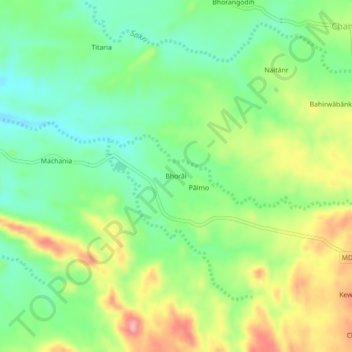
Name: Bhorai topographic map, elevation, terrain.
Location: Bhorai, Tisri, Giridih, Jharkhand, 815317, India (24.58259 86.00967 24.62259 86.04967)
Average elevation: 253 m
Minimum elevation: 204 m
Maximum elevation: 326 m
Thank you for supporting this site ❤️
Make a donation
Make a donation