
Make a donation
Madagascar topographic map
Click on the map to display elevation.
Make a donation
Madagascar
The prehistoric breakup of the supercontinent Gondwana resulted in the separation of East Gondwana (comprising Madagascar, Antarctica, Australia and the Indian subcontinent) and West Gondwana (Africa–South America) during the Jurassic period, around 185 million years ago. The Indo-Madagascar landmass separated from Antarctica and Australia around 125 million years ago and Madagascar separated from the Indian landmass about 84–92 million years ago during the Late Cretaceous. This long history of separation from other continents has allowed plants and animals on the island to evolve in relative isolation. Along the length of the eastern coast runs a narrow and steep escarpment containing much of the island's remaining tropical lowland forest. To the west of this ridge lies a plateau in the center of the island ranging in altitude from 750 to 1,500 m (2,460 to 4,920 ft) above sea level. These central highlands, traditionally the homeland of the Merina people and the location of their historic capital at Antananarivo, are the most densely populated part of the island and are characterized by terraced, rice-growing valleys lying between grassy hills and patches of the subhumid forests that formerly covered the highland region. To the west of the highlands, the increasingly arid terrain gradually slopes down to the Mozambique Channel and mangrove swamps along the coast.
Make a donation
About this map
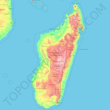
Name: Madagascar topographic map, elevation, terrain.
Location: Madagascar (-25.78402 42.96801 -11.73289 50.67273)
Average elevation: 139 m
Minimum elevation: -1 m
Maximum elevation: 2,568 m
Make a donation
Other topographic maps
Click on a map to view its topography, its elevation and its terrain.
Make a donation
Ankara
Ankara has a cold semi-arid climate (Köppen climate classification: BSk). Under the Trewartha climate classification, Ankara has a temperate humid continental climate (Dc). Due to its elevation and inland location, Ankara has cold and snowy winters, and hot and dry summers. Rainfall occurs mostly during the…
Average elevation: 1,082 m
Maharashtra
Maharashtra is the third largest state by area in India. The Western Ghats better known as Sahyadri, are a hilly range running parallel to the coast, at an average elevation of 1,200 metres (4,000 ft). Kalsubai, a peak in the Sahyadris, near Nashik city is the highest elevated point in Maharashtra. To the west…
Average elevation: 478 m
Make a donation
Thiruvananthapuram
India > Kerala > Thiruvananthapuram
Thiruvananthapuram is built on seven hills by the seashore and is at 8°30′N 76°54′E / 8.5°N 76.9°E / 8.5; 76.9 on the west coast, near the southern tip of mainland India. The city is on the west coast of India and is bounded by the Laccadive Sea to its west and the Western Ghats to its east.…
Average elevation: 33 m
Mumbai
Mumbai lies at the mouth of the Ulhas River on the western coast of India, in the coastal region known as the Konkan. It sits on Salsette Island (Sashti Island), which it partially shares with the Thane district. Mumbai is bounded by the Arabian Sea to the west. Many parts of the city lie just above sea level,…
Average elevation: 13 m
Make a donation
Mysuru
India > Karnataka > Mysuru taluk
Mysore (/maɪˈsɔːr/ (listen)), officially Mysuru ([ˈmaɪˈsuːɾu] (listen)), is a city in the southern part of the state of Karnataka, India. Mysore city is geographically located between 12° 18′ 26″ north latitude and 76° 38′ 59″ east longitude. It is located at an altitude of 770 m (2,530 ft)…
Average elevation: 727 m
Make a donation
Make a donation
Guwahati
Professor Abani Kumar Bhagawati of Gauhati University stated that since before there were sufficient wetlands to absorb rainwater and channels to carry excess water to the Brahmaputra, the city did not experience floods. However, human interference has disrupted the natural topography, leading to the current…
Average elevation: 113 m
Srinagar
India > Uttarakhand > Srinagar
Srinagar is located at 30°13′N 78°47′E / 30.22°N 78.78°E / 30.22; 78.78. at the left bank of Alaknanda river. It has an average elevation of 560 metres (1,837 feet). It is the largest town in the Garhwal Hills. It is reached by national highway NH58 from Rishikesh, Srinagar is about 104 km…
Average elevation: 859 m
Make a donation
Make a donation
Sonamarg
India > Jammu and Kashmir > Kangan
The hill station is situated in the Kashmir Valley, at an altitude of 2,730 metres (8,960 ft) Combined with the alpine meadows that bloom in the summer as well as rivers and lakes stocked with fish, Sonamarg is a notable tourist destination in Jammu and Kashmir.
Average elevation: 3,068 m
Secunderabad
Situated in the North of Hyderabad at 17°27′N 78°30′E / 17.45°N 78.5°E / 17.45; 78.5., Secunderabad lies on the northern part of the Deccan Plateau. Secunderabad has an average elevation of 543 metres (1781 ft). Most of the area has a rocky terrain and some areas are hilly.
Average elevation: 544 m
Leh
Leh (/ˈlɛ/) (Ladakhi: གླེ) is the joint capital and largest city of Ladakh, a union territory of India. Leh, located in the Leh district, was also the historical capital of the Kingdom of Ladakh, the seat of which was in the Leh Palace, the former residence of the royal family of Ladakh, built in the…
Average elevation: 4,294 m
Make a donation
Sohra (Cherrapunji)
India > Meghalaya > Shella Bholaganj
It has an average elevation of 1,430 metres (4,690 ft) and sits on a plateau in the southern part of the Khasi Hills, facing the plains of Bangladesh. The plateau rises 660 meters above the surrounding valleys.
Average elevation: 1,169 m
Kannur
India > Kerala > Kannur > Kannur
Kannur has an elevation of 1.02 metres or 3.3 feet along the coast of the Laccadive Sea, with a sandy coastal area. The city has an 8 kilometres (5.0 mi)-long seashore and a 3 kilometres (1.9 mi)-long beach at Payyambalam. Kannur is located north of Kozhikode, south of Kasargod and Mangalore, west of the…
Average elevation: 13 m
Make a donation
Yamuna River
The source of Yamuna lies in the Yamunotri Glacier at an elevation of 6,387 metres (20,955 ft), on the southwestern slopes of Banderpooch peaks, which lie in the Mussoorie range of the Lower Himalayas, north of Haridwar in Uttarkashi district, Uttarakhand. Yamunotri temple, a shrine dedicated to the goddess…
Average elevation: 206 m
Kandy
Kandy is located in the mountainous and thickly forested interior of the island. The city is located in between multiple mountain ranges including the Knuckles mountain range and the Hanthana Mountain Range, giving the city an elevation of 500 metres (1,600 ft) above sea level. It lies adjacent to the…
Average elevation: 621 m
Make a donation
Vadodara
India > Gujarat > Vadodara Rural Taluka
Vadodara is located at 22°18′N 73°11′E / 22.30°N 73.19°E / 22.30; 73.19 in western India at an elevation of 39 metres (128 ft). It is the tenth-largest city in India with an area of 400 square kilometres (150 sq mi) and a population of 3.5 million, according to the 2010–11 census. The city…
Average elevation: 36 m
Visakhapatnam
India > Andhra Pradesh > Visakhapatnam (Urban)
The city is situated between the Eastern Ghats and the Bay of Bengal. The city coordinates lies between 17.7041 N and 83.2977 E. The city's area is 682 km2. The average elevation is 45 metres. Visakhpatnam is situated in Coastal Andhra Region.
Average elevation: 35 m
Kolkata
Spread roughly north–south along the east bank of the Hooghly River, Kolkata sits within the lower Ganges Delta of eastern India approximately 75 km (47 mi) west of the international border with Bangladesh; the city's elevation is 1.5–9 m (5–30 ft). Much of the city was originally a wetland that was…
Average elevation: 5 m
Make a donation
Make a donation
Make a donation
Make a donation
Harapanahalli
India > Karnataka > Harapanahalli taluku
It has an average elevation of 633 metres (2,077 ft) above the Mean sea level. Harapanahalli is surrounded by several districts like Davanagere in the South, Chithradurga in the Southeast, Haveri in the West.
Average elevation: 626 m
Make a donation
Chennai
Chennai is located on the south–eastern coast of India in the north–eastern part of Tamil Nadu on a flat coastal plain known as the Eastern Coastal Plains. Its average elevation is around 6.7 metres (22 ft), and its highest point is 60 m (200 ft). Chennai is 2,184 kilometres (1,357 mi) south of Delhi,…
Average elevation: 7 m
Make a donation
Mussoorie
India > Uttarakhand > Dehradun
Mussoorie is at an average altitude of 2,005 metres (6,578 ft). To the northeast are the Himalayan snow ranges, and to the south, the Doon Valley and Shiwalik ranges. The second highest point is the original Lal Tibba in Landour, with a height of over 2,275 m (7,464 ft). Mussoorie is popularly known as The…
Average elevation: 1,594 m
Make a donation
Siliguri
India > West Bengal > Matigara block
Siliguri located at the foothills of the eastern Himalayas at a location of 26°43′N 88°26′E / 26.71°N 88.43°E / 26.71; 88.43. This city is spread over an area of 260 km2 within the Siliguri Corridor, also known as the Chicken's neck. The city is surrounded by dense forests towards north and…
Average elevation: 121 m
Make a donation
Anand
India > Gujarat > Anand City Taluka
Anand is located at 22°34′N 72°56′E / 22.57°N 72.93°E / 22.57; 72.93. It has an average elevation of 39 metres (127 feet). The city has an area of 22.7 square kilometres, and the urban area of Anand City is 172 square kilometres including 25 villages around the city.
Average elevation: 40 m
Dehradun
India > Uttarakhand > Dehradun
The city of Dehradun mainly lies in Doon Valley and is at a varying height from 410 m (1,350 ft) in Clement Town to above 700 m (2,300 ft) at Malsi which is 15 km (9.3 mi) from the city. However, the average elevation is 450 m (1,480 ft) above sea level. Malsi is the starting point of Lesser Himalayan Range…
Average elevation: 904 m
Bhubaneshwar
India > Odisha > Bhubaneswar (M.Corp.)
Bhubaneswar is in Khordha district of Odisha. It is in the eastern coastal plains, along the axis of the Eastern Ghats mountains. The city has an average altitude of 45 m (148 ft) above sea level. It lies southwest of the Mahanadi River that forms the northern boundary of Bhubaneswar metropolitan area, within…
Average elevation: 30 m
Make a donation
Make a donation
Akluj
India > Maharashtra > Malshiras
Akluj is in Malshiras tehsil and is 120 km (75 mi) away from Solapur city. It is located on the right bank of Nira River. The elevation of Akluj is 551 m (1,808 ft). The latitude 17.9000 and longitude 75.0333. The altitude in feet 1581 Lat (DMS) north 17° 53' 60 N Long (DMS) east 75° 1' 60E altitude (meters)…
Average elevation: 491 m
Car Nicobar Island
India > Andaman and Nicobar Islands > Car Nicobar > Malacca
Average elevation: 11 m
Adilabad
India > Telangana > Adilabad Urban Mandal
Adilabad has an average elevation of 264 metres. The district shares its boundaries with Nirmal districts of Telangana to the south, Komaram Bheem district on the east, with Nanded on the west and Yavatmal and Chandrapur districts of Maharashtra to the north.
Average elevation: 310 m
Make a donation
Anakapalle
India > Andhra Pradesh > Anakapalle
Anakapalli is located at 17°41′29″N 83°00′14″E / 17.6913°N 83.0039°E / 17.6913; 83.0039, on the banks of River Sarada and at an altitude of 29 m (95 ft). It is spread over an area of 23.28 km2 (8.99 sq mi).
Average elevation: 35 m
Make a donation
Dras
Dras (also spelt Drass, ISO transliteration: Drās), also known locally in Shina as Himababs, Hembabs, or Humas, is a town and hill station, near Kargil in the Kargil district of the union territory of Ladakh in India. It is on the NH 1 between Zoji La pass and Kargil. A tourist hub for its high-altitude…
Average elevation: 3,531 m
Make a donation
Bahraich
India > Uttar Pradesh > Bahraich
It has an average elevation of 126 metres (413 feet). Bahraich has a warm humid subtropical climate with hot summers from April to July. The rainy season is from July to mid-September when Bahraich gets an average rainfall from the south-west monsoon winds, and occasionally frontal rainfall will occur in…
Average elevation: 120 m
Make a donation
Make a donation