
Make a donation
Alberta topographic map
Click on the map to display elevation.
Make a donation
About this map
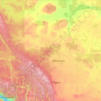
Name: Alberta topographic map, elevation, terrain.
Location: Alberta, Canada (48.99667 -120.00138 60.00047 -110.00476)
Average elevation: 806 m
Minimum elevation: 0 m
Maximum elevation: 3,512 m
Make a donation
Other topographic maps
Click on a map to view its topography, its elevation and its terrain.
Mount Royal
Canada > Quebec > Urban agglomeration of Montreal > Montreal
The mountain is part of the Monteregian Hills situated between the Laurentians and the Appalachian Mountains. It gave its Latin name, Mons Regius, to the Monteregian chain. The mountain consists of three peaks: Colline de la Croix (or Mont Royal proper) at 233 m (764 ft), Colline d'Outremont (or Mount Murray,…
Average elevation: 111 m
Toronto
Despite its deep ravines, Toronto is not remarkably hilly, but its elevation does increase steadily away from the lake. Elevation differences range from 76.5 metres (251 ft) above sea level at the Lake Ontario shore to 209 m (686 ft) ASL near the York University grounds in the city's north end at the…
Average elevation: 113 m
Make a donation
Make a donation
Make a donation
Saint Andrews
Canada > New Brunswick > Charlotte County > Town of Saint Andrews
Average elevation: 7 m
Dog Lake
Canada > Ontario > Thunder Bay District > Unorganized Thunder Bay District
Average elevation: 310 m
Make a donation
Make a donation
Make a donation
Stoney Creek
Canada > British Columbia > Regional District of Central Kootenay > Area K (The Arrow Lakes)
Average elevation: 1,295 m
London
London has a humid continental climate (Köppen Dfb), though due to its downwind location relative to Lake Huron and elevation changes across the city, it is virtually on the Dfa/Dfb (hot summer) boundary favouring the former climate zone to the southwest of the confluence of the South and North Thames Rivers,…
Average elevation: 269 m
Make a donation
Southgate River
Canada > British Columbia > Strathcona Regional District > Area B (Discovery Islands/Mainland Inlets)
Average elevation: 1,787 m
Map Glacier
Canada > British Columbia > Cariboo Regional District > Area J (West Chilcotin)
Average elevation: 2,037 m
Apple Hill
Canada > Ontario > Stormont, Dundas and Glengarry Counties > North Glengarry
Average elevation: 90 m
Make a donation
Make a donation
Shabuskwia Lake
Canada > Ontario > Thunder Bay District > Unorganized Thunder Bay District
Average elevation: 332 m
Make a donation
Alah Lake
Canada > British Columbia > Cariboo Regional District > Area F (Horsefly/Likely/150 Mile House)
Average elevation: 841 m
Highest Peak
Canada > British Columbia > Sunshine Coast Regional District > Area F (West Howe Sound) > Plumper Cove
Average elevation: 42 m
Make a donation
Make a donation
Williams Lake
Canada > British Columbia > Cariboo Regional District > Williams Lake
Average elevation: 854 m
Make a donation
Prince Rupert
Canada > British Columbia > North Coast Regional District > Prince Rupert
Prince Rupert Airport (YPR/CYPR) is on Digby Island. Its position is 54°17′10″N 130°26′41″W / 54.28611°N 130.44472°W / 54.28611; -130.44472, and its elevation is 35 m (116 ft) above sea level. The airport consists of one runway, one passenger terminal, and two aircraft stands. Access to…
Average elevation: 139 m
Slave Island
Canada > British Columbia > Regional District of Mount Waddington > Area B (Quatsino Sound/Cape Scott)
Average elevation: 15 m
Make a donation
Saskatoon
Canada > Saskatchewan > Saskatoon (city) > Saskatoon
Saskatoon lies on a long belt of rich, potassic chernozem in middle-southern Saskatchewan and is found in the aspen parkland biome. The lack of surrounding mountainous topography gives the city a relatively flat grid, though the city does sprawl over a few hills and into a few valleys. The lowest point in the…
Average elevation: 510 m
The International Falls
Canada > Ontario > Rainy River District > Fort Frances
Average elevation: 341 m
Plattsville
Canada > Ontario > Oxford County > Blandford-Blenheim > Plattsville
Average elevation: 315 m
Make a donation
Milbury Lake
Canada > Nova Scotia > Municipality of the County of Annapolis > Youngs Cove
Average elevation: 163 m
Make a donation
Cochrane
Canada > Alberta > Town of Cochrane > Cochrane
Cochrane is situated at the base of Big Hill in the Bow River Valley. It sits at an elevation of 1,186 m (3,891 ft). The town is intersected by Highway 1A and Highway 22. Cochrane has a reputation for its western culture, which can easily be felt when one wanders the streets (particularly Main Street). The…
Average elevation: 1,205 m
Prince George
Canada > British Columbia > Regional District of Fraser-Fort George > Prince George
Average elevation: 708 m
Make a donation