
仙台市 topographic map
Interactive map
Click on the map to display elevation.
About this map
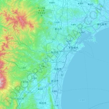
Name: 仙台市 topographic map, elevation, terrain.
Location: 仙台市, Präfektur Miyagi, Japan (38.05085 140.46947 38.45470 141.26030)
Average elevation: 185 m
Minimum elevation: -3 m
Maximum elevation: 1,799 m
In der Vergangenheit war es in dem Sendai-Gebiet bereits zu zahlreichen Flut- und Tsunami-Katastrophen gekommen. Wie aus dem Nihon Sandai Jitsuroku belegt ist, überflutete der Jōgan-Tsunami im Jahr 869 die Küstenebene von Sendai großflächig und tötete über 1.000 Menschen, doch sind bisher keine historischen Informationen bekannt, die die Tsunamihöhe oder die Größe der Tsunamiüberflutungsgebiete im Falle des Jōgan-Tsunamis und des Keichō-Tsunamis quantifizieren können.
Other topographic maps
Click on a map to view its topography, its elevation and its terrain.
北海道
Japan > Region Hokkaidō > 足寄町
北海道, 足寄町, 足寄郡, 十勝総合振興局, Präfektur Hokkaido, Region Hokkaidō, Japan
Average elevation: 98 m
Bucht von Tokio
Bucht von Tokio, 川崎区, Kawasaki, Präfektur Kanagawa, Japan
Average elevation: 0 m