
Thank you for supporting this site ❤️
Make a donation
Make a donation
Naqamte topographic map
Click on the map to display elevation.
Thank you for supporting this site ❤️
Make a donation
Make a donation
Naqamte
Nekemte, also spelled as Neqemte (Oromo: Naqamtee, Amharic: ነቀምት), is a market city and separate woreda in western Ethiopia. Located in the East Welega Zone of the Oromia Region, Nekemte has a latitude and longitude of 9°5′N 36°33′E / 9.083°N 36.550°E / 9.083; 36.550 and an elevation of 2,088 meters.
Thank you for supporting this site ❤️
Make a donation
Make a donation
About this map
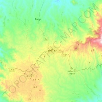
Name: Naqamte topographic map, elevation, terrain.
Location: Naqamte, East Wellega, Oromia Region, Ethiopia (8.93052 36.38816 9.25052 36.70816)
Average elevation: 1,909 m
Minimum elevation: 1,433 m
Maximum elevation: 3,030 m
Thank you for supporting this site ❤️
Make a donation
Make a donation
Other topographic maps
Click on a map to view its topography, its elevation and its terrain.