
Sikkim topographic map
Interactive map
Click on the map to display elevation.
About this map
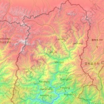
Name: Sikkim topographic map, elevation, terrain.
Location: Sikkim, India (27.07940 88.01203 28.12264 88.92137)
Average elevation: 3,786 m
Minimum elevation: 264 m
Maximum elevation: 8,447 m
Situated in the Himalayan mountains, the state of Sikkim is characterised by mountainous terrain. Almost the entire state is hilly, with an elevation ranging from 280 metres (920 ft) in the south at the border with West Bengal to 8,586 metres (28,169 ft) in northern peaks near Nepal and Tibet. The summit of Kangchenjunga, the world's third-highest peak, is the state's highest point, situated on the border between Sikkim and Nepal. For the most part, the land is unfit for agriculture because of the rocky, precipitous slopes. However, some hill slopes have been converted into terrace farms.
Other topographic maps
Click on a map to view its topography, its elevation and its terrain.
Hyderabad
India > Telangana > Bahadurpura mandal
Hyderabad, Bahadurpura mandal, Hyderabad District, Telangana, India
Average elevation: 549 m
Bhatwari
Bhatwari, Uttarkashi District, Uttarakhand, India
Average elevation: 4,570 m
Ooty Lake
India > Tamil Nadu > Udhagamandalam > Udhagamandalam
Ooty Lake, Udhagamandalam, The Nilgiris District, Tamil Nadu, 643001, India
Average elevation: 2,235 m
Vadodara
India > Gujarat > Vadodara Taluka
Vadodara, Vadodara Taluka, Vadodara District, Gujarat, 390001, India
Average elevation: 36 m
Huzur Nagar Tahsil
Huzur Nagar Tahsil, Rewa District, Madhya Pradesh, India
Average elevation: 145 m
Thiruvananthapuram
India > Kerala > Thiruvananthapuram
Thiruvananthapuram, Thiruvananthapuram District, Kerala, 695001, India
Average elevation: 33 m
Begur Lake
India > Karnataka > Bangalore South
Begur Lake, Beguru, Bangalore South, Bengaluru Urban, Karnataka, India
Average elevation: 904 m
Polavaram
India > Andhra Pradesh > Kanigiri
Polavaram, Kanigiri, Prakasam, Andhra Pradesh, India
Average elevation: 93 m
Darjeeling district
Darjeeling district, West Bengal, India
Average elevation: 728 m
Navi Mumbai
India > Maharashtra > Thane > Navi Mumbai
Navi Mumbai, Mumbai Metropolitan Region, Thane, Maharashtra, 400706, India
Average elevation: 30 m
Noida
India > Uttar Pradesh > Dadri
Noida, Dadri, Gautam Buddha Nagar District, Uttar Pradesh, 201301, India
Average elevation: 216 m
Surat
India > Gujarat > Katargam Taluka > Surat
Surat, Katargam Taluka, Surat, Gujarat, 395001, India
Average elevation: 11 m
Bengaluru
India > Karnataka > Bangalore North
Bengaluru, Bangalore North, Bengaluru Urban District, Karnataka, India
Average elevation: 881 m
Asarva Taluka
Asarva Taluka, Ahmedabad District, Gujarat, India
Average elevation: 57 m
Nagrota
India > Himachal Pradesh > Jawali
Nagrota, Jawali, Kangra District, Himachal Pradesh, 176027, India
Average elevation: 461 m
Naya Gurha
India > Rajasthan > Gogunda Tehsil
Naya Gurha, Gogunda Tehsil, Udaipur District, Rajasthan, 313011, India
Average elevation: 725 m
3d
India > Rajasthan > Ganganagar Tehsil > 1 LNP
3d, 1 LNP, Ganganagar Tehsil, Sri Ganganagar District, Rajasthan, India
Average elevation: 178 m
Anaikatti
India > Tamil Nadu > Coimbatore North
Anaikatti, Mannarkad, Palakkad District, Kerala, 678741, India
Average elevation: 623 m
Musi River
Musi River, Hyderabad, Uppal mandal, Medchal–Malkajgiri, Telangana, 5000036, India
Average elevation: 490 m
Dahej
India > Gujarat > Vagra Taluka
Dahej, Vagra Taluka, Bharuch District, Gujarat, 393125, India
Average elevation: 6 m
Chennai
India > Tamil Nadu > Chennai
Chennai, Chennai District, Tamil Nadu, India
Average elevation: 8 m
Rishikesh
India > Uttarakhand > Rishikesh
Rishikesh, Dehradun, Uttarakhand, 249201, India
Average elevation: 497 m
Dehradun
India > Uttarakhand > Dehradun
Dehradun, Dehradun District, Uttarakhand, 248001, India
Average elevation: 904 m
Madurai
India > Tamil Nadu > Madurai
Madurai, Madurai South, Madurai district, Tamil Nadu, India
Average elevation: 138 m
Askot
India > Uttarakhand > Didihat
Askot, Didihat, Pithoragarh District, Uttarakhand, 262543, India
Average elevation: 1,058 m
Tarikhet
India > Uttarakhand > Ranikhet
Tarikhet, Ranikhet, Almora District, Uttarakhand, 263645, India
Average elevation: 1,525 m
Kinnakorai
India > Tamil Nadu > Kundah
Kinnakorai, Kundah, Nilgiris District, Tamil Nadu, India
Average elevation: 1,524 m