
Thank you for supporting this site ❤️
Make a donation
Make a donation
Zagreb topographic map
Click on the map to display elevation.
Thank you for supporting this site ❤️
Make a donation
Make a donation
Zagreb
Zagreb (/ˈzɑːɡrɛb, ˈzæɡrɛb, zɑːˈɡrɛb/ ZAH-greb, ZAG-reb, zah-GREB, Croatian: (listen)) is the capital and largest city of Croatia. It is in the northwest of the country, along the Sava river, at the southern slopes of the Medvednica mountain. Zagreb lies at an elevation of approximately 122 m (400 ft) above sea level. The estimated population of the city in 2018 was 804,507. The population of the Zagreb urban agglomeration is 1,153,255, approximately a quarter of the total population of Croatia.
Thank you for supporting this site ❤️
Make a donation
Make a donation
About this map
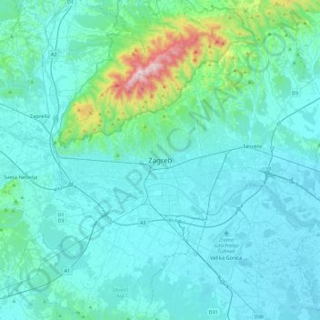
Name: Zagreb topographic map, elevation, terrain.
Location: Zagreb, City of Zagreb, 10106, Croatia (45.65318 15.81718 45.97318 16.13718)
Average elevation: 193 m
Minimum elevation: 96 m
Maximum elevation: 1,027 m
Thank you for supporting this site ❤️
Make a donation
Make a donation