
Thank you for supporting this site ❤️
Make a donation
Make a donation
Kotari topographic map
Click on the map to display elevation.
Thank you for supporting this site ❤️
Make a donation
Make a donation
About this map
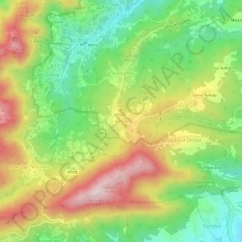
Name: Kotari topographic map, elevation, terrain.
Location: Kotari, Grad Samobor, Zagreb County, 10430, Croatia (45.72957 15.65402 45.76957 15.69402)
Average elevation: 469 m
Minimum elevation: 237 m
Maximum elevation: 759 m
Thank you for supporting this site ❤️
Make a donation
Make a donation