
Đakovo topographic map
Interactive map
Click on the map to display elevation.
About this map
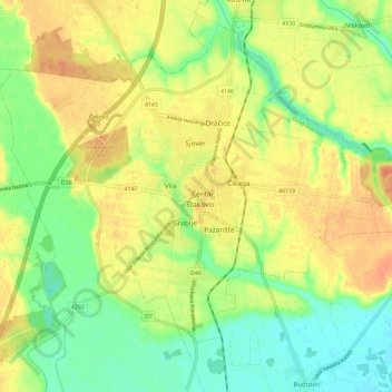
Name: Đakovo topographic map, elevation, terrain.
Location: Đakovo, Grad Đakovo, Osijek-Baranja County, 31400, Croatia (45.26970 18.37049 45.34970 18.45049)
Average elevation: 103 m
Minimum elevation: 82 m
Maximum elevation: 122 m
Đakovo is located 37 km (23 mi) to the southwest of Osijek and 34 km (21 mi) southeast of Našice; elevation 111 m. It is located near the motorway A5/E73, at the intersection of the state road D7 to Osijek, the arterial roads D38 to Požega, D46 to Vinkovci and the connecting road D515 to Našice.