
Montana topographic map
Interactive map
Click on the map to display elevation.
About this map
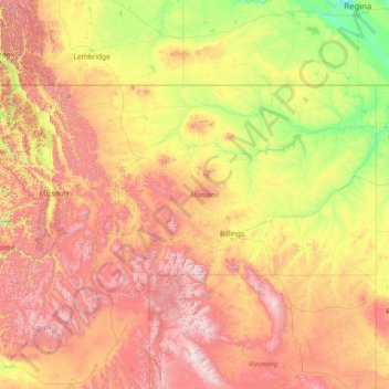
Name: Montana topographic map, elevation, terrain.
Location: Montana, United States (44.35792 -116.04923 49.00111 -104.03956)
Average elevation: 1,357 m
Minimum elevation: 552 m
Maximum elevation: 4,034 m
The state's topography is roughly defined by the Continental Divide, which splits much of the state into distinct eastern and western regions. Most of Montana's hundred or more named mountain ranges are in the state's western half, most of which is geologically and geographically part of the northern Rocky Mountains. The Absaroka and Beartooth ranges in the state's south-central part are technically part of the Central Rocky Mountains. The Rocky Mountain Front is a significant feature in the state's north-central portion, and isolated island ranges that interrupt the prairie landscape common in the central and eastern parts of the state. About 60 percent of the state is prairie, part of the northern Great Plains.
Other topographic maps
Click on a map to view its topography, its elevation and its terrain.
Snohomish County
Snohomish County, Washington, United States
Average elevation: 649 m
Tacoma
United States > Washington > Pierce County
Tacoma, Pierce County, Washington, United States
Average elevation: 67 m
Hickory Valley
United States > Tennessee > Hardeman County
Hickory Valley, Hardeman County, West Tennessee, Tennessee, 38042, United States
Average elevation: 176 m
Louisville
United States > Alabama > Barbour County
Louisville, Barbour County, Alabama, United States
Average elevation: 149 m
Chattanooga
United States > Tennessee > Hamilton County
Chattanooga, Hamilton County, East Tennessee, Tennessee, United States
Average elevation: 331 m
Raymertown
United States > New York > Rensselaer County > Town of Pittstown
Raymertown, Town of Pittstown, Rensselaer County, New York, United States
Average elevation: 180 m
Wilkinson County
Wilkinson County, Georgia, United States
Average elevation: 104 m
Marin County
Marin County, California, United States
Average elevation: 69 m
Worcester
United States > Massachusetts > Worcester County
Worcester, Worcester County, Massachusetts, United States
Average elevation: 186 m
Vantage
United States > Washington > Kittitas County > Vantage
Vantage, Kittitas County, Washington, United States
Average elevation: 222 m
Aurora Hill
United States > Nevada > Mineral County
Aurora Hill, Mineral County, Nevada, United States
Average elevation: 2,272 m
Schley County
Schley County, Georgia, 31806, United States
Average elevation: 148 m
Jenkins
United States > Missouri > Barry County
Jenkins, Barry County, Missouri, United States
Average elevation: 359 m
Porter
United States > Pennsylvania > Jefferson County > Porter Township
Porter, Porter Township, Jefferson County, Pennsylvania, 15763, United States
Average elevation: 481 m
San Diego
United States > California > San Diego County
San Diego, San Diego County, California, United States
Average elevation: 125 m
Hillman
United States > Minnesota > Morrison County
Hillman, Morrison County, Minnesota, 56338, United States
Average elevation: 400 m
Dallas
United States > Texas > Dallas County
Dallas, Dallas County, Texas, United States
Average elevation: 160 m
Stanford
United States > California > Santa Clara County > Palo Alto
Stanford, Palo Alto, Santa Clara County, California, United States
Average elevation: 40 m
Haywood County
United States > North Carolina
Haywood County, North Carolina, United States
Average elevation: 1,044 m
Sandy Hook Lighthouse
United States > New Jersey > Monmouth County > Middletown Township > Fort Hancock
Sandy Hook Lighthouse, Hudson Road, Fort Hancock, Middletown Township, Monmouth County, New Jersey, United States
Average elevation: 1 m
Thacher Park
United States > New Hampshire > Hillsborough County > Hancock
Thacher Park, Hancock, Hillsborough County, New Hampshire, United States
Average elevation: 365 m
Black Mountain
United States > North Carolina > Buncombe County
Black Mountain, Buncombe County, North Carolina, 28711, United States
Average elevation: 811 m
Thacher State Park
United States > New York > Albany County > Town of New Scotland
Thacher State Park, Town of New Scotland, Albany County, New York, United States
Average elevation: 262 m
Grants Pass
United States > Oregon > Josephine County
Grants Pass, Josephine County, Oregon, United States
Average elevation: 377 m
Town of Stony Point
United States > New York > Rockland County
Town of Stony Point, Rockland County, New York, United States
Average elevation: 119 m
Calvin
United States > West Virginia > Nicholas County
Calvin, Nicholas County, West Virginia, 26660, United States
Average elevation: 708 m
Agency Lake
United States > Oregon > Klamath County
Agency Lake, Klamath County, Oregon, United States
Average elevation: 1,266 m
Pinnacle Point
United States > Utah > Emery County
Pinnacle Point, Emery County, Utah, United States
Average elevation: 1,848 m
Kalahari Indoor Waterpark
United States > Wisconsin > Sauk County > Wisconsin Dells
Kalahari Indoor Waterpark, 1305, Kalahari Drive, Wisconsin Dells, Sauk County, Wisconsin, 53965, United States
Average elevation: 290 m
Yachats
United States > Oregon > Lincoln County
Yachats, Lincoln County, Oregon, United States
Average elevation: 53 m
Hinton
United States > Iowa > Plymouth County
Hinton, Plymouth County, Iowa, 51204, United States
Average elevation: 362 m
Lake Tahoe
United States > California > Placer County
Lake Tahoe, Placer County, California, United States
Average elevation: 2,077 m
Show Low
United States > Arizona > Navajo County
Show Low, Navajo County, Arizona, 85901, United States
Average elevation: 1,957 m
Sierra Vista Open Space Preserve
United States > California > Santa Clara County > San Jose
Sierra Vista Open Space Preserve, San Jose, Santa Clara County, California, United States
Average elevation: 484 m
Earthaven Ecovillage
United States > North Carolina > Rutherford County
Earthaven Ecovillage, Rutherford County, North Carolina, United States
Average elevation: 693 m
Turtle River
United States > Minnesota > Beltrami County
Turtle River, Beltrami County, Minnesota, United States
Average elevation: 405 m
Briartown
United States > Kentucky > Washington County > Springfield
Briartown, Springfield, Washington County, Kentucky, 40069, United States
Average elevation: 233 m
Warila Land
United States > Massachusetts > Worcester County > Harvard
Warila Land, Stow Road, Harvard, Worcester County, Massachusetts, 01719, United States
Average elevation: 93 m
Pittsburgh
United States > Pennsylvania > Allegheny County
Pittsburgh, Allegheny County, Pennsylvania, United States
Average elevation: 303 m
West Hollywood
West Hollywood, California, United States
Average elevation: 122 m
Central Camp
United States > California > Madera County
Central Camp, Madera County, California, United States
Average elevation: 1,745 m
Nordheim
United States > Texas > DeWitt County
Nordheim, DeWitt County, Texas, United States
Average elevation: 120 m