
Dodge County topographic map
Click on the map to display elevation.
About this map
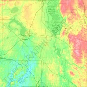
Name: Dodge County topographic map, elevation, terrain.
Location: Dodge County, Wisconsin, United States (43.19469 -89.00921 43.63348 -88.40022)
Average elevation: 278 m
Minimum elevation: 237 m
Maximum elevation: 370 m
Other topographic maps
Click on a map to view its topography, its elevation and its terrain.
Kalahari Indoor Waterpark
United States > Wisconsin > Sauk County > Wisconsin Dells
Average elevation: 290 m