
Thank you for supporting this site ❤️
Make a donation
Make a donation
Pong topographic map
Click on the map to display elevation.
Thank you for supporting this site ❤️
Make a donation
Make a donation
About this map
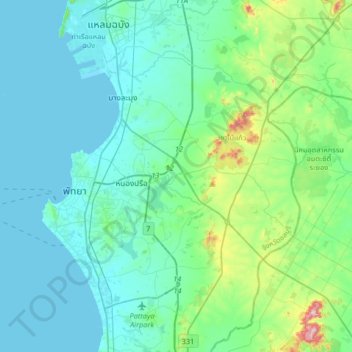
Name: Pong topographic map, elevation, terrain.
Location: Pong, Chon Buri Province, Thailand (12.79057 100.82119 13.11057 101.14119)
Average elevation: 61 m
Minimum elevation: 0 m
Maximum elevation: 406 m
Thank you for supporting this site ❤️
Make a donation
Make a donation