
Make a donation
Tirbin EAC topographic map
Click on the map to display elevation.
Make a donation
About this map
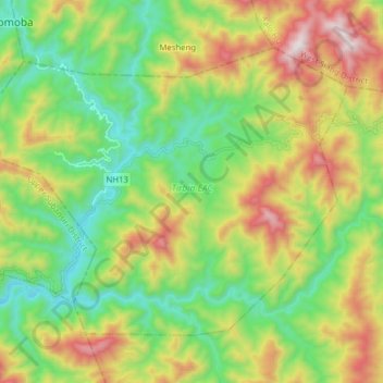
Name: Tirbin EAC topographic map, elevation, terrain.
Average elevation: 775 m
Minimum elevation: 388 m
Maximum elevation: 1,444 m
Make a donation
Other topographic maps
Click on a map to view its topography, its elevation and its terrain.
Itanagar
India > Arunachal Pradesh > Itanagar EAC
Itanagar is located at 27°06′N 93°37′E / 27.1°N 93.62°E / 27.1; 93.62. It has an average elevation of 320 metres.
Average elevation: 539 m
Tawang
India > Arunachal Pradesh > Tawang Circle
Tawang is situated 448 km north-west of state capital Itanagar at an elevation of approximately 3,048 metres (10,000 ft). It lies to the north of the Tawang Chu river valley, roughly 10 miles (16 km) south of the Line of Actual Control with China. It is the site of a famous Gelugpa Buddhist Monastery.
Average elevation: 3,280 m
Make a donation
Make a donation
Make a donation
Make a donation
Make a donation
Pasighat
India > Arunachal Pradesh > Pasighat HQ
Pasighat is located at 28°04′N 95°20′E / 28.07°N 95.33°E / 28.07; 95.33. It has an average elevation of 153 metres or 502 feet. Pasighat has a typical lowland Northeast India humid subtropical climate (Köppen Cwa) a little too cool to qualify as a tropical monsoon climate (Am).
Average elevation: 179 m
Make a donation
Make a donation
Anini
India > Arunachal Pradesh > Anini Circle
The small settlement of Anini is located at an elevation of 1,968 metres (6,457 ft) above sea level. On the Aninese Plateau, the average elevation is 1,800 meters, but the average elevation of the town is 2,068 meters. According to Google Maps' terrain feature, Anini is around 1,600–1,800 meters above sea…
Average elevation: 1,660 m
Make a donation
Make a donation
Make a donation
Make a donation
Koloriang
India > Arunachal Pradesh > Koloriang HQ
Koloriang is a hilly district headquarters town of Kurung Kumey district in Arunachal Pradesh, India, bordering Tibet. It has an altitude of 1,000 metres (3,300 ft) and is surrounded by high mountains all around and is located in the right bank of river Kurung, one of the major tributaries of Subansiri river.…
Average elevation: 1,791 m
Khonsa
India > Arunachal Pradesh > Khonsa HQ
Khonsa is located at 27°01′N 95°34′E / 27.02°N 95.57°E / 27.02; 95.57. It has an average elevation of 1215 metres (3986 feet).
Average elevation: 858 m
Make a donation
Naharlagun
India > Arunachal Pradesh > Naharlagun EAC
It is at an altitude of 155 metres (509 ft) from sea level. Surrounded by mountains, Naharlagun is a city which sees annual long monsoon rains. The weather is sub-tropical, with hot and humid summer and temperate winter.
Average elevation: 254 m
Make a donation
Make a donation
Make a donation
Make a donation
Make a donation
Make a donation
Make a donation
Make a donation
Sela-Pass
India > Arunachal Pradesh > Dirang ADC
The Sela Pass (Tibetan: གཟེ་ལ།) (more appropriately called Se La, as La means Pass in Tibetan language) is a high-altitude mountain pass located on the border between the Tawang and West Kameng districts in the Indian state of Arunachal Pradesh. It has an elevation of 4170 m (13,700 ft) and…
Average elevation: 4,073 m
Make a donation
Make a donation
Make a donation
Make a donation
Sela-Pass
India > Arunachal Pradesh > Dirang ADC
The Sela Pass (Tibetan: གཟེ་ལ།) (more appropriately called Se La, as La means Pass in Tibetan language) is a high-altitude mountain pass located on the border between the Tawang and West Kameng districts in the Indian state of Arunachal Pradesh. It has an elevation of 4170 m (13,700 ft) and…
Average elevation: 4,073 m
Make a donation