
Thank you for supporting this site ❤️
Make a donation
Make a donation
Naharlagun topographic map
Click on the map to display elevation.
Thank you for supporting this site ❤️
Make a donation
Make a donation
Naharlagun
It is at an altitude of 155 metres (509 ft) from sea level. Surrounded by mountains, Naharlagun is a city which sees annual long monsoon rains. The weather is sub-tropical, with hot and humid summer and temperate winter.
Thank you for supporting this site ❤️
Make a donation
Make a donation
About this map
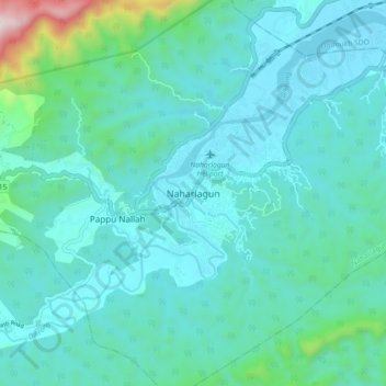
Name: Naharlagun topographic map, elevation, terrain.
Average elevation: 254 m
Minimum elevation: 119 m
Maximum elevation: 1,096 m
Thank you for supporting this site ❤️
Make a donation
Make a donation