
Punjab topographic map
Interactive map
Click on the map to display elevation.
About this map
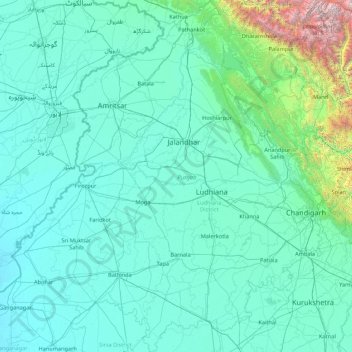
Name: Punjab topographic map, elevation, terrain.
Location: Punjab, India (29.54294 73.87983 32.51118 76.93906)
Average elevation: 477 m
Minimum elevation: 170 m
Maximum elevation: 6,027 m
Punjab is in northwestern India and has a total area of 50,362 square kilometres (19,445 sq mi). Punjab is bordered by Pakistan's Punjab province on the west, Jammu and Kashmir on the north, Himachal Pradesh on the northeast and Haryana and Rajasthan on the south. Most of Punjab lies in a fertile, alluvial plain with perennial rivers and an extensive irrigation canal system. A belt of undulating hills extends along the northeastern part of the state at the foot of the Himalayas. Its average elevation is 300 metres (980 ft) above sea level, with a range from 180 metres (590 ft) in the southwest to more than 500 metres (1,600 ft) around the northeast border. The southwest of the state is semi-arid, eventually merging into the Thar Desert. Of the five Punjab rivers, three—Sutlej, Beas and Ravi—flow through the Indian state. The Sutlej and Ravi define parts of the international border with Pakistan.
Other topographic maps
Click on a map to view its topography, its elevation and its terrain.
Hyderabad
India > Telangana > Bahadurpura mandal
Hyderabad, Bahadurpura mandal, Hyderabad District, Telangana, India
Average elevation: 549 m
Bengaluru
India > Karnataka > Bangalore North
Bengaluru, Bangalore North, Bengaluru Urban District, Karnataka, India
Average elevation: 881 m
Chennai
India > Tamil Nadu > Chennai
Chennai, Chennai District, Tamil Nadu, India
Average elevation: 8 m
Kolambi
India > Maharashtra > Velhe
Kolambi, Velhe, Pune District, Maharashtra, India
Average elevation: 773 m
Darjeeling district
Darjeeling district, West Bengal, India
Average elevation: 728 m
Devanahalli
India > Karnataka > Devanahalli taluk
Devanahalli, Devanahalli taluk, Bengaluru Rural District, Karnataka, 562110, India
Average elevation: 900 m
Dehradun
India > Uttarakhand > Dehradun
Dehradun, Dehradun District, Uttarakhand, 248001, India
Average elevation: 904 m
Madurai
India > Tamil Nadu > Madurai
Madurai, Madurai South, Madurai district, Tamil Nadu, India
Average elevation: 138 m
Mustarivadi
India > Karnataka > Humanabad taluku
Mustarivadi, Humanabad taluku, Bidar District, Karnataka, India
Average elevation: 629 m
Polavaram
India > Andhra Pradesh > Kanigiri
Polavaram, Kanigiri, Prakasam, Andhra Pradesh, India
Average elevation: 93 m
Gorakhpur
Gorakhpur, Gorakhpur District, Uttar Pradesh, 273165, India
Average elevation: 90 m
Noida
India > Uttar Pradesh > Dadri
Noida, Dadri, Gautam Buddha Nagar District, Uttar Pradesh, 201301, India
Average elevation: 216 m
Surat
India > Gujarat > Katargam Taluka > Surat
Surat, Katargam Taluka, Surat, Gujarat, 395001, India
Average elevation: 11 m
Kurud
India > Chhattisgarh > Kurud Tahsil
Kurud, Kurud Tahsil, Dhamtari District, Chhattisgarh, 493663, India
Average elevation: 310 m
Yelahanka taluku
Yelahanka taluku, Bengaluru Urban, Karnataka, India
Average elevation: 898 m
3d
India > Rajasthan > Ganganagar Tehsil > 1 LNP
3d, 1 LNP, Ganganagar Tehsil, Sri Ganganagar District, Rajasthan, India
Average elevation: 178 m
Kanyakumari district
Kanyakumari district, Tamil Nadu, India
Average elevation: 226 m
Musi River
Musi River, Hyderabad, Uppal mandal, Medchal–Malkajgiri, Telangana, 5000036, India
Average elevation: 490 m
Ooty Lake
India > Tamil Nadu > Udhagamandalam > Udhagamandalam
Ooty Lake, Udhagamandalam, The Nilgiris District, Tamil Nadu, 643001, India
Average elevation: 2,235 m
Panvel
India > Maharashtra > Panvel > Panvel
Panvel, Raigad, Maharashtra, 410206, India
Average elevation: 75 m
Mahadevpura
India > Madhya Pradesh > Kailaras Tahsil > Bastoli
Mahadevpura, Bastoli, Kailaras Tahsil, Morena District, Madhya Pradesh, India
Average elevation: 187 m
Dahej
India > Gujarat > Vagra Taluka
Dahej, Vagra Taluka, Bharuch District, Gujarat, 393125, India
Average elevation: 6 m
Thiruvananthapuram
India > Kerala > Thiruvananthapuram
Thiruvananthapuram, Thiruvananthapuram District, Kerala, 695001, India
Average elevation: 33 m
Navi Mumbai
India > Maharashtra > Thane > Navi Mumbai
Navi Mumbai, Mumbai Metropolitan Region, Thane, Maharashtra, 400706, India
Average elevation: 30 m
Vadodara
India > Gujarat > Vadodara Taluka
Vadodara, Vadodara Taluka, Vadodara District, Gujarat, 390001, India
Average elevation: 36 m
Jaipur
India > Rajasthan > Jaipur Tehsil
Jaipur, Jaipur Municipal Corporation, Jaipur Tehsil, Jaipur District, Rajasthan, 302001, India
Average elevation: 408 m
Aamdi
India > Madhya Pradesh > Mahidpur Tahsil > Kajikhedi
Aamdi, Kajikhedi, Mahidpur Tahsil, Ujjain District, Madhya Pradesh, India
Average elevation: 482 m
Kurud
India > Maharashtra > Chamorshi Taluka
Kurud, Chamorshi Taluka, Gadchiroli District, Maharashtra, India
Average elevation: 191 m
Kunra
India > Madhya Pradesh > Damoh Tahsil > Ranjara
Kunra, Ranjara, Damoh Tahsil, Damoh District, Madhya Pradesh, India
Average elevation: 343 m
Virane
India > Maharashtra > Malegaon
Virane, Malegaon, Nashik District, Maharashtra, India
Average elevation: 545 m
Barwi
India > Madhya Pradesh > Maheshwar Tahsil
Barwi, Maheshwar Tahsil, Khargone District, Madhya Pradesh, India
Average elevation: 180 m
Shedol
India > Maharashtra > Nilanga
Shedol, Nilanga, Latur District, Maharashtra, 413521, India
Average elevation: 619 m
syahi devi
India > Uttarakhand > Almora > Almora
syahi devi, Almora, Almora District, Uttarakhand, 263600, India
Average elevation: 1,738 m