
Krishna River topographic map
Interactive map
Click on the map to display elevation.
About this map
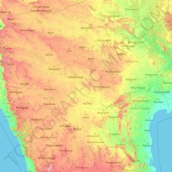
Name: Krishna River topographic map, elevation, terrain.
Location: Krishna River, India (15.71365 73.63803 17.98908 81.13360)
Average elevation: 407 m
Minimum elevation: -1 m
Maximum elevation: 1,831 m
The Krishna river originates in the Western Ghats near Mahabaleshwar at an elevation of about 1,300 metres, in the state of Maharashtra in central India. It is one of the longest rivers in India. The Krishna river is around 1,400 km in length (282 KM in Maharashtra). The Krishna river's source is at Mahabaleshwar near the Jor village in the extreme north of Wai Taluka, Satara District, Maharashtra in the west and empties into the Bay of Bengal at Hamasaladeevi (near Koduru) in Andhra Pradesh, on the east coast. It flows through the state of Karnataka before entering Telangana State. The delta of this river is one of the most fertile regions in India and was the home to ancient Satavahana and Ikshvaku Sun Dynasty kings. Vijayawada is the largest city on the River Krishna.
Other topographic maps
Click on a map to view its topography, its elevation and its terrain.
Thiruvananthapuram
India > Kerala > Thiruvananthapuram
Thiruvananthapuram, Thiruvananthapuram District, Kerala, 695001, India
Average elevation: 33 m
Hyderabad
India > Telangana > Bahadurpura mandal
Hyderabad, Bahadurpura mandal, Hyderabad District, Telangana, India
Average elevation: 549 m
Dehradun
India > Uttarakhand > Dehradun
Dehradun, Dehradun District, Uttarakhand, 248001, India
Average elevation: 904 m
3d
India > Rajasthan > Ganganagar Tehsil > 1 LNP
3d, 1 LNP, Ganganagar Tehsil, Sri Ganganagar District, Rajasthan, India
Average elevation: 178 m
Anaikatti
India > Tamil Nadu > Coimbatore North
Anaikatti, Coimbatore North, Coimbatore District, Tamil Nadu, 678741, India
Average elevation: 623 m
kursari
India > Jammu and Kashmir > Bhaderwah
kursari, Bhaderwah, Doda District, Jammu and Kashmir, 182222, India
Average elevation: 1,719 m
Tillari Dam
India > Maharashtra > Dodamarg Taluka
Tillari Dam, Dodamarg Taluka, Sindhudurg District, Maharashtra, India
Average elevation: 90 m
Bengaluru
India > Karnataka > Bangalore North
Bengaluru, Bangalore North, Bengaluru Urban District, Karnataka, India
Average elevation: 881 m
Banagudi
India > Tamil Nadu > Kotagiri
Banagudi, Kotagiri, Nilgiris District, Tamil Nadu, 643201, India
Average elevation: 1,548 m
Ithalar
India > Tamil Nadu > Kundah
Ithalar, Kundah, Nilgiris District, Tamil Nadu, 643004, India
Average elevation: 2,060 m
Kodali
India > Maharashtra > Udgir
Kodali, Udgir, Latur District, Maharashtra, India
Average elevation: 508 m
Musi River
Musi River, Hyderabad, Uppal mandal, Medchal–Malkajgiri, Telangana, 5000036, India
Average elevation: 490 m
Mangaluru
India > Karnataka > Mangaluru taluk
Mangaluru, Mangaluru taluk, Dakshina Kannada District, Karnataka, 575001, India
Average elevation: 25 m
Siliguri
India > West Bengal > Siliguri Subdivsion
Siliguri, Siliguri Subdivsion, Darjeeling District, West Bengal, India
Average elevation: 121 m
Pavana Dam
India > Maharashtra > Mawal > Kale Colony
Pavana Dam, Kale Colony, Mawal, Pune District, Maharashtra, 410406, India
Average elevation: 610 m
Bhatwari
Bhatwari, Uttarkashi District, Uttarakhand, India
Average elevation: 4,570 m
Ooty Lake
India > Tamil Nadu > Udhagamandalam > Udhagamandalam
Ooty Lake, Udhagamandalam, The Nilgiris District, Tamil Nadu, 643001, India
Average elevation: 2,235 m
Kurabalakota
Kurabalakota, Annamayya, Andhra Pradesh, India
Average elevation: 699 m
Bhaderwah
Bhaderwah, Doda District, Jammu and Kashmir, 182222, India
Average elevation: 2,511 m
Mamidipalle
India > Telangana > Kandi mandal
Mamidipalle, Kandi mandal, Sangareddy District, Telangana, 502001, India
Average elevation: 525 m
Tirupati
India > Andhra Pradesh > Tirupati (Urban)
Tirupati, Tirupati (Urban), Tirupati, Andhra Pradesh, 517500, India
Average elevation: 319 m
Vadodara
India > Gujarat > Vadodara Rural Taluka
Vadodara, Vadodara Rural Taluka, Vadodara District, Gujarat, 390001, India
Average elevation: 36 m
Surat
India > Gujarat > Katargam Taluka > Surat
Surat, Katargam Taluka, Surat, Gujarat, 395001, India
Average elevation: 11 m
Jaipur
India > Rajasthan > Jaipur Tehsil
Jaipur, Jaipur Municipal Corporation, Jaipur Tehsil, Jaipur District, Rajasthan, 302001, India
Average elevation: 408 m
Bhopal
India > Madhya Pradesh > Huzur Tahsil
Bhopal, Huzur Tahsil, Bhopal District, Madhya Pradesh, 462001, India
Average elevation: 498 m
Pir Panjal Range
India > Jammu and Kashmir > Mandi tehsil
Pir Panjal Range, Mandi tehsil, Poonch District, Jammu and Kashmir, India
Average elevation: 3,285 m
Mukhathala Kulam
India > Kerala > Kollam > Thrikkovilvattom
Mukhathala Kulam, Thrikkovilvattom, Kollam, Kollam District, Kerala, India
Average elevation: 18 m
Raura
India > Madhya Pradesh > Mangawan Tahsil
Raura, Mangawan Tahsil, Rewa District, Madhya Pradesh, India
Average elevation: 301 m
Riwai Village
India > Meghalaya > Pynursla > Nohwet Village
Riwai Village, Nohwet Village, Pynursla, East Khasi Hills District, Meghalaya, India
Average elevation: 430 m
Poomala Dam
India > Kerala > Thrissur > Thrissur
Poomala Dam, Thrissur, Thrissur District, Kerala, 680581, India
Average elevation: 99 m
Poomala
India > Kerala > Thodupuzha
Poomala, Thodupuzha, Idukki District, Kerala, 685591, India
Average elevation: 255 m
Cheppara
India > Kerala > Talappilly > Thrissur
Cheppara, Poonamala Road, Thrissur, Talappilly, Thrissur District, Kerala, 680028, India
Average elevation: 101 m
Letibunga
India > Uttarakhand > Dhari
Letibunga, Dhari, Nainital District, Uttarakhand, 263132, India
Average elevation: 1,970 m
Gogina
India > Uttarakhand > Bhikiasain > Manila
Gogina, Manila, Bhikiasain, Almora District, Uttarakhand, 263667, India
Average elevation: 1,447 m
Gudisa
India > Andhra Pradesh > Maredumilli
Gudisa, Maredumilli, Alluri Sitharama Raju, Andhra Pradesh, India
Average elevation: 974 m
Kanyakumari district
Kanyakumari district, Tamil Nadu, India
Average elevation: 226 m
Brahmaur
Brahmaur, Chamba District, Himachal Pradesh, 176315, India
Average elevation: 3,708 m