
Make a donation
Mannargudi topographic map
Click on the map to display elevation.
Make a donation
About this map
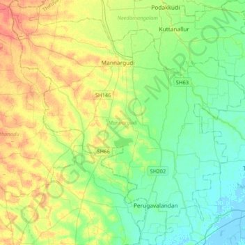
Name: Mannargudi topographic map, elevation, terrain.
Location: Mannargudi, Thiruvarur District, Tamil Nadu, India (10.43286 79.30238 10.74735 79.61054)
Average elevation: 15 m
Minimum elevation: -2 m
Maximum elevation: 38 m
Make a donation
Other topographic maps
Click on a map to view its topography, its elevation and its terrain.
Madurai
India > Tamil Nadu > Madurai
Madurai is located at 9°56′N 78°07′E / 9.93°N 78.12°E / 9.93; 78.12. It has an average elevation of 101 metres. The city of Madurai lies on the flat and fertile plain of the river Vaigai, which runs in the northwest-southeast direction through the city, dividing it into two almost equal…
Average elevation: 138 m
Make a donation
Chennai
Chennai is located on the south–eastern coast of India in the north–eastern part of Tamil Nadu on a flat coastal plain known as the Eastern Coastal Plains. Its average elevation is around 6.7 metres (22 ft), and its highest point is 60 m (200 ft). Chennai is 2,184 kilometres (1,357 mi) south of Delhi,…
Average elevation: 7 m
Make a donation
Vellore
India > Tamil Nadu > Vellore
Vellore is at 12°55′N 79°08′E / 12.92°N 79.13°E / 12.92; 79.13, 220m above sea level. The city has a tropical savanna climate. It is in the Vellore district of the South Indian state, Tamil Nadu, 135 km (84 mi) west of the state capital Chennai and 30 km (19 mi) kms South of its twin city…
Average elevation: 283 m
Chengalpattu
India > Tamil Nadu > Chengalpattu
Chengalpattu is located at 12°42′N 79°59′E / 12.7°N 79.98°E / 12.7; 79.98. It has an average elevation of 36 metres (118 ft). Lake Kolavai is the largest located in Chengalpattu.
Average elevation: 48 m
Make a donation
Palladam
India > Tamil Nadu > Palladam
Palladam is located at 10°59′N 77°18′E / 10.98°N 77.3°E / 10.98; 77.3. It has an average elevation of 325 metres (1,066 feet). Palladam is located near to Tirupur (14 km away) which is called the 'Dollar City' of Tamil Nadu, 15 km from the village of Putharachal and located 38 km east of the…
Average elevation: 377 m
Mettupalayam
India > Tamil Nadu > Mettupalayam
Mettupalayam is located at 11°18′00″N 76°57′00″E / 11.3000°N 76.9500°E / 11.3000; 76.9500. It has an average elevation of 314 metres (1033 feet). Mettupalayam is situated on the bank of Bhavani River at the foot of the Nilgiri mountains.
Average elevation: 321 m
Make a donation
Salem
Salem is located at 11°40′N 78°08′E / 11.67°N 78.14°E / 11.67; 78.14, at an average elevation of 278 m (912 ft). The city is surrounded by hills: Nagaramalai on the north, Jarugumalai on the south, Kanjamalai on the west, Godumalai on the east and the Shevaroy Hills on the northeast.…
Average elevation: 418 m
Kanchipuram
Kanchipuram is located at 12°50′19″N 79°42′06″E / 12.8387°N 79.7016°E / 12.8387; 79.7016, 72 km (45 mi) south-west of Chennai on the banks of the Vegavathi River, a tributary of the Palar River. The city covers an area of 11.6 km2 (4.5 sq mi) and has an elevation of 83.2 m (273 ft) above…
Average elevation: 82 m
Make a donation
Make a donation
Make a donation
Arani
India > Tamil Nadu > Arani
Arni is located at 12°40′N 79°17′E / 12.67°N 79.28°E / 12.67; 79.28 on the banks of the Kamandala Naaga river. It has an average elevation of 151 metres (495 ft).
Average elevation: 143 m
Make a donation
Make a donation
Make a donation
Make a donation
Make a donation
Make a donation
Tirunelveli
India > Tamil Nadu > Palayamkottai
Tirunelveli is located at 8°43′41.82″N 77°41′43.94″E / 8.7282833°N 77.6955389°E / 8.7282833; 77.6955389, and its average elevation is 47 metres (154 ft). It is located at the southernmost tip of the Deccan plateau. The Tamirabarani River divides the city into the Tirunelveli quarter and…
Average elevation: 34 m
Make a donation
Make a donation
Make a donation
Make a donation
Make a donation
Make a donation
Make a donation
Make a donation
Make a donation
Make a donation
Jolarpet
India > Tamil Nadu > Tirupathur
Jolarpet is a second grade municipality in Tirupattur district. Jolarpet is renowned for its railway station. The town is also located on State Highway 18 connecting Vaniyambadi -Tirupattur. Regarding transportation linkage, the highway (NH 48) from Chennai to Krishnagiri passes through the outskirts of the…
Average elevation: 493 m
Make a donation
Thanjavur
India > Tamil Nadu > Thanjavur
Thanjavur is located at 10°48′N 79°09′E / 10.8°N 79.15°E / 10.8; 79.15 The tributaries of river Cauvery, namely, the Grand Anaicut canal (Pudhaaru), Vadavaaru and Vennaaru rivers flow through the city. Thanjavur is situated in the Cauvery delta, at a distance of 314 km (195 mi) south-west of…
Average elevation: 49 m
Make a donation