
British Columbia topographic map
Interactive map
Click on the map to display elevation.
British Columbia
British Columbia's topography is a testament to its diverse and dramatic landscapes. Dominated by the Cordillera region, the province features prominent mountain ranges such as the Coast Mountains in the west and the Rocky Mountains in the east. The Coast Mountains, composed of granite rocks from the Cretaceous and Tertiary periods, are deeply incised by long, twisting fjords that extend inland from the Pacific Ocean. In contrast, the Rocky Mountains, characterized by sedimentary formations, present rugged peaks and the expansive Rocky Mountain Trench—a 1,400 km (870 miles) valley that channels the headwaters of major rivers like the Columbia and Fraser. Between these ranges lies the Interior Plateau, a broad expanse of gently rolling uplands carved by rivers such as the Fraser, which has etched deep canyons into the bedrock. This varied terrain supports a range of ecosystems, from the dense temperate rainforests along the coast to the semi-arid grasslands of the southern interior valleys.
About this map
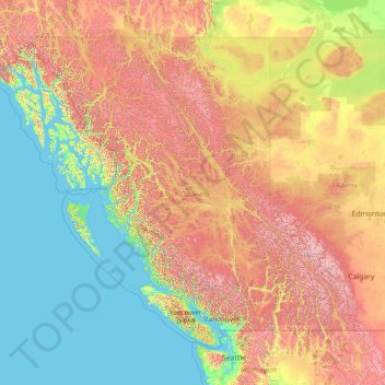
Name: British Columbia topographic map, elevation, terrain.
Location: British Columbia, Canada (48.22456 -139.06133 60.00207 -114.05414)
Average elevation: 708 m
Minimum elevation: -3 m
Maximum elevation: 3,625 m
Other topographic maps
Click on a map to view its topography, its elevation and its terrain.
Mount Royal
Canada > Quebec > Urban agglomeration of Montreal > Montreal
The mountain is part of the Monteregian Hills situated between the Laurentians and the Appalachian Mountains. It gave its Latin name, Mons Regius, to the Monteregian chain. The mountain consists of three peaks: Colline de la Croix (or Mont Royal proper) at 233 m (764 ft), Colline d'Outremont (or Mount Murray,…
Average elevation: 111 m
Dog Lake
Canada > Ontario > Thunder Bay District > Unorganized Thunder Bay District
Average elevation: 310 m
Saint Andrews
Canada > New Brunswick > Charlotte County > Town of Saint Andrews
Average elevation: 7 m
Map Glacier
Canada > British Columbia > Cariboo Regional District > Area J (West Chilcotin)
Average elevation: 2,037 m
Highest Peak
Canada > British Columbia > Sunshine Coast Regional District > Area F (West Howe Sound) > Plumper Cove
Average elevation: 42 m
Alah Lake
Canada > British Columbia > Cariboo Regional District > Area F (Horsefly/Likely/150 Mile House)
Average elevation: 841 m
Shabuskwia Lake
Canada > Ontario > Thunder Bay District > Unorganized Thunder Bay District
Average elevation: 332 m
Southgate River
Canada > British Columbia > Strathcona Regional District > Area B (Discovery Islands/Mainland Inlets)
Average elevation: 1,787 m
London
London has a humid continental climate (Köppen Dfb), though due to its downwind location relative to Lake Huron and elevation changes across the city, it is virtually on the Dfa/Dfb (hot summer) boundary favouring the former climate zone to the southwest of the confluence of the South and North Thames Rivers,…
Average elevation: 269 m
Stoney Creek
Canada > British Columbia > Regional District of Central Kootenay > Area K (The Arrow Lakes)
Average elevation: 1,295 m
Apple Hill
Canada > Ontario > Stormont, Dundas and Glengarry Counties > North Glengarry
Average elevation: 90 m
Toronto
Despite its deep ravines, Toronto is not remarkably hilly, but its elevation does increase steadily away from the lake. Elevation differences range from 76.5 metres (251 ft) above sea level at the Lake Ontario shore to 209 m (686 ft) ASL near the York University grounds in the city's north end at the…
Average elevation: 113 m
Milbury Lake
Canada > Nova Scotia > Municipality of the County of Annapolis > Youngs Cove
Average elevation: 163 m
The International Falls
Canada > Ontario > Rainy River District > Fort Frances
Average elevation: 341 m
Slave Island
Canada > British Columbia > Regional District of Mount Waddington > Area B (Quatsino Sound/Cape Scott)
Average elevation: 15 m
Prince Rupert
Canada > British Columbia > North Coast Regional District > Prince Rupert
Prince Rupert Airport (YPR/CYPR) is on Digby Island. Its position is 54°17′10″N 130°26′41″W / 54.28611°N 130.44472°W / 54.28611; -130.44472, and its elevation is 35 m (116 ft) above sea level. The airport consists of one runway, one passenger terminal, and two aircraft stands. Access to…
Average elevation: 139 m
Regina
Canada > Saskatchewan > Regina
Unlike other planned cities in the Canadian West, on its treeless flat plain Regina has few topographical features other than the small spring run-off, Wascana Creek. Early planners took advantage of such opportunity by damming the creek to create a decorative lake to the south of the central business district…
Average elevation: 582 m
Plattsville
Canada > Ontario > Oxford County > Blandford-Blenheim > Plattsville
Average elevation: 315 m
Cochrane
Canada > Alberta > Town of Cochrane > Cochrane
Cochrane is situated at the base of Big Hill in the Bow River Valley. It sits at an elevation of 1,186 m (3,891 ft). The town is intersected by Highway 1A and Highway 22. Cochrane has a reputation for its western culture, which can easily be felt when one wanders the streets (particularly Main Street). The…
Average elevation: 1,205 m