
Make a donation
Manipur topographic map
Click on the map to display elevation.
Make a donation
Manipur
The state lies at a latitude of 23°83'N – 25°68'N and a longitude of 93°03'E – 94°78'E. The total area covered by the state is 22,327 square kilometres (8,621 sq mi). The capital lies in an oval-shaped valley of approximately 700 square miles (2,000 km2), surrounded by blue mountains, at an elevation of 790 metres (2,590 ft) above sea level. The slope of the valley is from north to south. The mountain ranges create a moderated climate, preventing the cold winds from the north from reaching the valley and barring cyclonic storms.
Make a donation
About this map
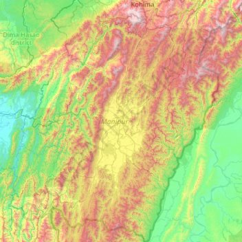
Name: Manipur topographic map, elevation, terrain.
Location: Manipur, India (23.83362 92.97071 25.69210 94.74524)
Average elevation: 810 m
Minimum elevation: 19 m
Maximum elevation: 2,997 m
Make a donation
Other topographic maps
Click on a map to view its topography, its elevation and its terrain.
Maharashtra
Maharashtra is the third largest state by area in India. The Western Ghats better known as Sahyadri, are a hilly range running parallel to the coast, at an average elevation of 1,200 metres (4,000 ft). Kalsubai, a peak in the Sahyadris, near Nashik city is the highest elevated point in Maharashtra. To the west…
Average elevation: 478 m
Make a donation
Dehradun
India > Uttarakhand > Dehradun
The city of Dehradun mainly lies in Doon Valley and is at a varying height from 410 m (1,350 ft) in Clement Town to above 700 m (2,300 ft) at Malsi which is 15 km (9.3 mi) from the city. However, the average elevation is 450 m (1,480 ft) above sea level. Malsi is the starting point of Lesser Himalayan Range…
Average elevation: 904 m
Make a donation
Patna
India > Bihar > Patna Rural
Patna is on the southern bank of the river Ganges. The total area of Patna is 250 km2 (97 sq mi). Of this, the municipal area constitutes 109.218 km2 (42.169 sq mi). The suburban area covers 140.782 km2 (54.356 sq mi). It has an average elevation of 53 m (174 ft). A characteristic feature of the geography of…
Average elevation: 51 m
Make a donation
Salem
Salem is located at 11°40′N 78°08′E / 11.67°N 78.14°E / 11.67; 78.14, at an average elevation of 278 m (912 ft). The city is surrounded by hills: Nagaramalai on the north, Jarugumalai on the south, Kanjamalai on the west, Godumalai on the east and the Shevaroy Hills on the northeast.…
Average elevation: 418 m
Mumbai
Mumbai lies at the mouth of the Ulhas River on the western coast of India, in the coastal region known as the Konkan. It sits on Salsette Island (Sashti Island), which it partially shares with the Thane district. Mumbai is bounded by the Arabian Sea to the west. Many parts of the city lie just above sea level,…
Average elevation: 13 m
Make a donation
Leh
Leh (/ˈlɛ/) (Ladakhi: གླེ) is the joint capital and largest city of Ladakh, a union territory of India. Leh, located in the Leh district, was also the historical capital of the Kingdom of Ladakh, the seat of which was in the Leh Palace, the former residence of the royal family of Ladakh, built in the…
Average elevation: 4,294 m
Guwahati
Professor Abani Kumar Bhagawati of Gauhati University stated that since before there were sufficient wetlands to absorb rainwater and channels to carry excess water to the Brahmaputra, the city did not experience floods. However, human interference has disrupted the natural topography, leading to the current…
Average elevation: 113 m
Make a donation
Make a donation
Make a donation
Make a donation
Make a donation
Chennai
Chennai is located on the south–eastern coast of India in the north–eastern part of Tamil Nadu on a flat coastal plain known as the Eastern Coastal Plains. Its average elevation is around 6.7 metres (22 ft), and its highest point is 60 m (200 ft). Chennai is 2,184 kilometres (1,357 mi) south of Delhi,…
Average elevation: 7 m
Make a donation
Western Ghats
The range starts near south of the Tapti river and runs approximately 1,600 km (990 mi) through the states of Gujarat, Maharashtra, Karnataka, Goa, Kerala and Tamil Nadu ending at Marunthuvazh Malai, Swamithope near the southern tip of India. These hills cover 160,000 km2 (62,000 sq mi) and form the catchment…
Average elevation: 2,225 m
Make a donation
Shimla
Shimla is on the south-western ranges of the Himalayas at 31°37′N 77°06′E / 31.61°N 77.10°E / 31.61; 77.10. It has an average altitude of 2,206 metres (7,238 ft) above mean sea level and extends along a ridge with seven spurs. The city stretches nearly 9.2 kilometres (5.7 mi) from east to west.
Average elevation: 1,557 m
Manipal
India > Karnataka > Udupi taluku
Manipal is a suburb and university town within Udupi, in coastal Karnataka, India. Manipal is located five kilometres away from the centre of Udupi City, in Udupi District, Karnataka (state) in south western India. It is administered by the Udupi City Municipality. The suburb is located in coastal Karnataka,…
Average elevation: 32 m
Dharamshala
India > Himachal Pradesh > Dharamshala
Dharamshala has an average elevation of 1,457 m (4,780 ft), covering an area of almost 8.51 km2 (3.29 sq mi). Dharamsala is located in the Kangra Valley, in the shadow of the Dhauladhar mountains.
Average elevation: 1,781 m
Make a donation
Srinagar
India > Jammu and Kashmir > Srinagar (South)
Under the Köppen climate classification, Srinagar has a four-season humid subtropical climate (Cfa) with hot summers and cool winters. The valley is surrounded by the Himalayas on all sides. Due to influence from Himalayan rain shadow and western disturbances, Srinagar has year-round precipitation; the spring…
Average elevation: 1,805 m
Kolkata
Spread roughly north–south along the east bank of the Hooghly River, Kolkata sits within the lower Ganges Delta of eastern India approximately 75 km (47 mi) west of the international border with Bangladesh; the city's elevation is 1.5–9 m (5–30 ft). Much of the city was originally a wetland that was…
Average elevation: 5 m
Vengurla
India > Maharashtra > Vengurla Taluka
Vengurla is located at 15°52′N 73°38′E / 15.87°N 73.63°E / 15.87; 73.63. It has an average elevation of 11 metres (36 ft). Vengurla is also known as Vingoria. It includes areas such as Dabholi, Khanoli, Vetore, Tendoli, Wayangani, Surangpani, Shiroda, Redi.
Average elevation: 36 m
Make a donation
Rajampet
India > Andhra Pradesh > Rajampet
Rajampeta is a town in Annamayya district of the Indian state of Andhra Pradesh, located in the Rayalaseema Region formed on the banks of Cheyyeru River. The town has an average elevation of 139 meters (456 ft).
Average elevation: 147 m
Make a donation
Erattupetta
It has an average elevation of 36 metres (118 feet).
Average elevation: 78 m
Make a donation
Make a donation
Make a donation
Sonamarg
India > Jammu and Kashmir > Kangan
The hill station is situated in the Kashmir Valley, at an altitude of 2,730 metres (8,960 ft) Combined with the alpine meadows that bloom in the summer as well as rivers and lakes stocked with fish, Sonamarg is a notable tourist destination in Jammu and Kashmir.
Average elevation: 3,068 m
Kargil
India > Ladakh > Kargil tehsil
Kargil has an average elevation of 2,676 metres (8,780 feet), and is situated along the banks of the Suru River (Indus). The town of Kargil is located 205 km (127 mi) from Srinagar, facing the Northern Areas across the LOC. Like other areas in the Himalayas, Kargil has a temperate climate. Summers are hot with…
Average elevation: 3,262 m
Make a donation
Almora
India > Uttarakhand > Almora
Almora is located at 29°35′50″N 79°39′33″E / 29.5971°N 79.6591°E / 29.5971; 79.6591 in Almora district in Uttarakhand. Almora is situated 365 km north-east the national capital New Delhi and 415 km south-east the state capital Dehradun. It lies in the revenue Division Kumaon and is located…
Average elevation: 1,557 m
Thiruvananthapuram
India > Kerala > Thiruvananthapuram
Thiruvananthapuram is built on seven hills by the seashore and is at 8°30′N 76°54′E / 8.5°N 76.9°E / 8.5; 76.9 on the west coast, near the southern tip of mainland India. The city is on the west coast of India and is bounded by the Laccadive Sea to its west and the Western Ghats to its east.…
Average elevation: 33 m
Bikaner
India > Rajasthan > Bikaner Tehsil
Around a century after Rao Bika founded Bikaner, the state's fortunes flourished under the sixth Raja, Rai Singhji, who ruled from 1571 to 1611. During the Mughal Empire's rule in the country, Raja Rai Singh accepted the suzerainty of the Mughals and held a high rank as an army general at the court of the…
Average elevation: 225 m
Make a donation
Bathinda
India > Punjab > Bathinda Tahsil
Bathinda is in the northwestern region of India and is a part of the Indo-Gangetic alluvial plains. The exact cartographic co-ordinates of Bathinda are 30°12′N 74°57′E / 30.20°N 74.95°E / 30.20; 74.95. It has an average elevation of 201 metres (660 ft).
Average elevation: 208 m
Make a donation
Visakhapatnam
India > Andhra Pradesh > Visakhapatnam (Urban)
The city is situated between the Eastern Ghats and the Bay of Bengal. The city coordinates lies between 17.7041 N and 83.2977 E. The city's area is 682 km2. The average elevation is 45 metres. Visakhpatnam is situated in Coastal Andhra Region.
Average elevation: 35 m
Madurai
India > Tamil Nadu > Madurai
Madurai is located at 9°56′N 78°07′E / 9.93°N 78.12°E / 9.93; 78.12. It has an average elevation of 101 metres. The city of Madurai lies on the flat and fertile plain of the river Vaigai, which runs in the northwest-southeast direction through the city, dividing it into two almost equal…
Average elevation: 138 m
Make a donation
Make a donation
Make a donation
Make a donation
Make a donation