
Make a donation
Kota topographic map
Click on the map to display elevation.
Make a donation
About this map
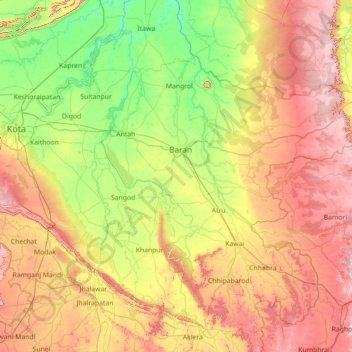
Name: Kota topographic map, elevation, terrain.
Location: Kota, Baran, Rajasthan, India (24.36000 75.86000 25.64000 77.14000)
Average elevation: 320 m
Minimum elevation: 191 m
Maximum elevation: 534 m
Make a donation
Other topographic maps
Click on a map to view its topography, its elevation and its terrain.
Karauli
The Chambal River forms the southeastern boundary of the district with the state of Madhya Pradesh, around 5 kilometres (3.1 mi) away from Mandrayal. Although most of Karauli district is composed of hills and valleys, there are no high mountains, with the highest having an elevation less than 450 metres (1,480…
Average elevation: 263 m
Make a donation
Dausa
The general topographic elevation in the district is between 250 m to 300 m above sea level. Elevation ranges from a minimum of 203.2 m above sea level in Mahwa in the northeastern part of the district and maximum of 596.3 m above sea level in Bandikui in northern part of the district.
Average elevation: 313 m
Make a donation
Make a donation
Sirohi
Sirohi District is broken up by hills and rocky ranges. The granite massif of Mount Abu divides the district into two portions, running from north-east to south-west. The south and south-east part of the district, which lies between Mount Abu and the main spine of the Aravallis, is mountainous and rugged, and…
Average elevation: 351 m
Make a donation
Pali
The Aravalli Range forms the eastern boundary of the district, and the southern boundary ends at Bamnera village in Sumerpur Tehsil. There are foothills to the west, through which run some Luni River tributaries. The western portion of the district includes the alluvial plain of the Luni. The district is…
Average elevation: 377 m
Make a donation
Make a donation
Jodhpur District
The district is located in the State of Rajasthan in western India. The district is bounded on the north by Bikaner District, on the northeast by Nagaur District, on the southeast and south by Pali District, on the southwest by Barmer District, and on the west and northwest by Jaisalmer District. The district…
Average elevation: 228 m
Make a donation
Make a donation
Make a donation
Make a donation
Pratapgarh
Pratapgarh is located at 24.03° N 74.78° E with an average elevation of 580 meters (1610 feet above mean sea level). It is said to be the second highest place (?) in Rajasthan after Mount Abu. Situated on the junction of the Aravali mountain ranges and the Malwa Plateau its unique location prominently…
Average elevation: 390 m
Jalore
The district is bounded on the northwest by Balotra District, on the northeast by Pali District, on the southeast by Sirohi District, and by Banaskantha District of Gujarat state on the southwest. The total area of the district is 10,640 km2 (4,108 sq mi). The altitude is 268 m, latitude is 25.22 N and…
Average elevation: 183 m
Make a donation
Make a donation
Make a donation
Make a donation
Behror Tehsil
Located at co-ordinates 27°53′N 76°17′E / 27.88°N 76.28°E / 27.88; 76.28. with an average elevation of 312 metres (1,024 ft) Behror sits amidst generally plain and very fertile agricultural land with Aravali Range mountains running north–south approximately 5 km to west of Behror.
Average elevation: 325 m
Make a donation
Haldighati Park
India > Rajasthan > Sanganer Tehsil > Jaipur Municipal Corporation
Average elevation: 372 m
Make a donation
Kumbhalgarh Fort
India > Rajasthan > Kumbhalgarh Tehsil > Quila Kumbhalgarh > Aret
Average elevation: 876 m
Make a donation
Make a donation
Ranvir shekhawat park
India > Rajasthan > Sanganer Tehsil > Jaipur Municipal Corporation
Average elevation: 413 m
karauli
India > Rajasthan > Karauli Tehsil
Karauli is located at 26°30′N 77°01′E / 26.5°N 77.02°E / 26.5; 77.02. It has an average elevation of 275 metres (902 ft).
Average elevation: 273 m
Make a donation
Make a donation
Pokaran
India > Rajasthan > Pokaran Tehsil
Pokhran is located 112 km east of Jaisalmer city, 172 km northwest of Jodhpur and 225 km south of Bikaner by road. It lies on Jaisalmer to Jodhpur railway line. It is situated at 27°05′42″N 71°45′11″E / 27.095°N 71.753°E / 27.095; 71.753 and has an average elevation of 233 metres (764 feet).
Average elevation: 229 m
Make a donation
Padampur
India > Rajasthan > Padampur Tehsil
Located in southwest of the Ganganagar district, the city has an average elevation of 165 metres (541 ft)
Average elevation: 169 m
Make a donation
Make a donation
Chittorgarh Fort
India > Rajasthan > Chittaurgarh Tehsil > Chittauri > Chittauri Ka Khera
Average elevation: 427 m
Make a donation
Make a donation