
Thank you for supporting this site ❤️
Make a donation
Make a donation
Bathinda topographic map
Click on the map to display elevation.
Thank you for supporting this site ❤️
Make a donation
Make a donation
Bathinda
Bathinda is in the northwestern region of India and is a part of the Indo-Gangetic alluvial plains. The exact cartographic co-ordinates of Bathinda are 30°12′N 74°57′E / 30.20°N 74.95°E / 30.20; 74.95. It has an average elevation of 201 metres (660 ft).
Thank you for supporting this site ❤️
Make a donation
Make a donation
About this map
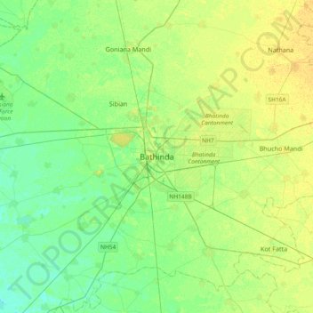
Name: Bathinda topographic map, elevation, terrain.
Location: Bathinda, Bathinda Tahsil, Bathinda, Punjab, 151001, India (30.04679 74.78637 30.36679 75.10637)
Average elevation: 208 m
Minimum elevation: 199 m
Maximum elevation: 218 m
Thank you for supporting this site ❤️
Make a donation
Make a donation